STATE KEEPS EYES ON DAMS

RICHARD WALKER / RWALKER@STARBULLETIN.COM
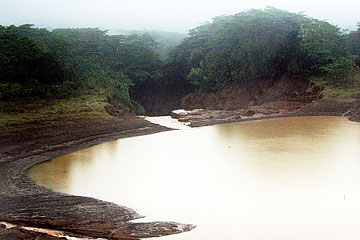
Civil Defense and county and state officials flew over parts of Kauai yesterday in a National Guard Black Hawk helicopter to inspect damage from recent heavy rains. Ka Loko Reservoir, with its broken dam wall, can be seen in the background.
|
|
Aerial views show scope of damage
The scars where water breached Ka Loko Dam are clearly visible
LIHUE » From above, the scars where water breached Ka Loko Dam are clearly visible. But it appears efforts to lower the water level of the reservoir behind the dam are working.
Teams of state, federal and county engineers and dam experts have been monitoring and assessing the situation at several dams on Kauai since Wednesday.
Yesterday morning, one of the teams, accompanied by state Civil Defense Vice Director Ed Teixeira and University of Hawaii engineering professor Horst Brandes, flew a helicopter over nine dams, including Ka Loko, to see their condition firsthand.
At a news conference afterward, Teixeira said he noticed that the water level at Ka Loko appeared lower than what he has seen in pictures taken immediately after the dam breach on Tuesday.
"From day one to now, the water level has dropped down considerably," Teixeira said.
From the vantage point of a Hawaii National Guard helicopter, Department of Land and Natural Resources personnel could be seen carrying a kayak into Ka Loko reservoir. Robert Masuda, DLNR deputy director, said the men are paddling into the reservoir with sonar and GPS equipment to sound the bottom so they can better calculate the volume of water left.
The Black Hawk helicopter made several passes around the rim of the reservoir so Brandes and DLNR engineer Dickee Lee could get a good view of what was going on below.
The size of the jagged cut in the dam rim and the rings, which show the water level before Tuesday, are an indication of the volume and the deadly force of the spilled-over water.
The helicopter had to turn back during its first attempt to fly over Ka Loko because of the rain and clouds. The engineers flew back over Waita Reservoir Dam and its spillway and then to Elua, near Opu Road in Kalaheo, Alexander, Pauaa, Kapaia, Twin, Upper and Lower Kapahi reservoirs and dams.
The aerial team and a ground team looked at 12 dams overall yesterday.
In the next week, there will be four teams of state, county and federal government engineers who will examine all 53 of the main dams and reservoirs on Kauai, Masuda said. He is on Kauai to help coordinate the effort, which includes the county, DLNR, the Army Corps of Engineers, the U.S. Geological Survey and possibly the U.S. Bureau of Reclamation.
Masuda said the engineers can get a better idea from an aerial view of the size and capacity of each dam, current water levels and the inflows and outflows from each reservoir.
The flyover, along with ground visits and other measurements, will assist them in calculating the volume of water in the reservoirs and determine what damage, if any, there has been from the rain and the Ka Loko Dam breach.
It is too early to draw any conclusions, Masuda said. But once the assessments are finished the results will be shared with the owners of the dams.

RICHARD WALKER / RWALKER@STARBULLETIN.COM
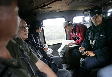
Taking part in a survey of flood damage on Kauai yesterday were Donald Fujimoto, left, Kauai County Department of Public Works engineer; Geotech engineer Tats Hirata; Dickie Lee, state Department of Land and Natural Resources Inspection Section head of engineering; University of Hawaii engineering professor Horst Brandes; and Solomon Kanoho, member of the Kauai Fire Department and Hawaii Urban Search & Rescue.
|
|
In addition to the dam assessments, the U.S. Geological Survey has brought to Kauai two remote sensors, which will be placed in critical reservoirs and can give an immediate indication via satellite and computer links if there are any changes in the water levels. More sensors can be brought in if needed, said Barry Hill, the agency's assistant district chief. The sensors can also be made permanent if warranted, he said.
Another team of geological survey scientists is working on calculating the volume and flow of the water that breached Ka Loko Dam to better understand what happened. That information, Hill said, may help prevent similar events from happening in the future.
Teams also have been landing, if possible, or driving and hiking up to the dams.
Donald Fujimoto, an engineer from Kauai County, took a first aerial glance yesterday at damage caused by the rains.
The most obvious flooding was at the Waialua Municipal Golf Course, which still had several fairways underwater. Fujimoto said he also noticed damage to county parks and the Lydgate Pond, which is normally clear but is now filled with tree trunks and other debris that will have to be cleared.
The damage assessment is just beginning, Fujimoto said. More helicopter flights will be needed before the full extent of the damage is known.
The group prepared to go up again yesterday afternoon, but as they left, the clouds that were over the north shore started moving south.
TO SEEK OR OFFER HELP
Here is a list of resources for victims of the Kauai dam disaster, along with contacts for those interested in donating to help in the recovery:
» Flood victims can contact the American Red Cross at 245-4919 for shelter, food, clothing and other household necessities.
» Victims can also call Aloha United Way's 211 help line to report damage and access services.
» To give to flood victims, contact the Hawaii Community Foundation at 566-5527 or e-mail kvierra@hcf-hawaii. org. Checks should be made out to the Kauai Island Fund and sent to the foundation at 1164 Bishop St., Honolulu, HI 97813.
» Donations can also be sent to the American Red Cross of Hawaii, marked for the Kauai disaster. Send checks to the Red Cross at 4155 Diamond Head Road, Honolulu, HI 96816, or donate online at www.hawaiiredcross.org. Contact the Red Cross at 739-8109.
|
CORRECTION
Tuesday, March 21, 2006
» The Waita Reservoir, mauka of Koloa and Poipu on Kauai, is monitored by Grove Farm Co. A graphic on Page A13 Sunday incorrectly said Alexander & Baldwin monitors the reservoir.
|

