U.S. NAVY / NATIONAL GEOPHYSICAL DATA CENTER
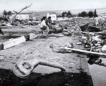
Hilo residents surveyed the damage from the May 22, 1960, tsunami generated by a huge quake off Chile.
|
|
Tsunami study looks past sea floor
STORY SUMMARY »
A University of Hawaii scientist has joined an international research effort aimed at improving understanding of how major earthquakes trigger powerful tsunamis.
UH geophysicist Gregory Moore is working with U.S. and Japanese scientists to try to learn why earthquakes below some parts of the ocean floor cause devastating tsunamis -- such as the 1944 Tonankai event that killed at least 1,200 people -- while those in other regions do not.
A 7.8-magnitude quake in Fiji yesterday, for instance, generated no destructive tsunami.
Aboard a commercial ship, Moore and colleagues have begun collecting three-dimensional seismic data revealing the structure of the Earth's crust below the Nankai Trough south of Japan.
STAR-BULLETIN
FULL STORY »
A University of Hawaii scientist is co-leader of an international research effort aimed at improving understanding of how major earthquakes trigger powerful tsunamis.
"If we can develop criteria for locations, magnitudes and depths of fault slips that might generate tsunamis, the early warning system might be better able to know whether or not to put out a tsunami warning after a quake," UH geophysicist Gregory Moore said in an e-mail from Japan.
He is working with U.S. and Japanese scientists to try to learn why earthquakes below some parts of the ocean floor cause devastating tsunamis -- such as the 1944 Tonankai event that killed at least 1,200 people -- while those in other regions do not.
Some quakes, like yesterday's, create no wave
Not all quakes do a tsunami make.
A 7.8-magnitude earthquake yesterday south of Fiji, for instance, generated no destructive tsunami.
Generally speaking, sections of the Earth's crust that slip sideways -- like the San Andreas fault in California -- do not generate seismic sea waves. More dangerous are places where one tectonic plate slips under another : subduction zones. Those areas include the Aleutian Islands, Kamchatka in the Russian Far East and Chile.
The tsunami that struck Hawaii on April 1, 1946, killing 159 people in Hilo, was generated by a relatively small 7.1 quake in the Aleutians. An 8.3 quake in the Aleutians generated a much less destructive tsunami that hit Hawaii in 1957.
An 8.3 quake in Chile generated a tsunami that killed 61 people in Hilo in 1960.
STAR-BULLETIN STAFF
|
The team is investigating one of the Earth's most active earthquake zones: the Nankai Trough beneath the ocean off Japan's southwest coast.
The goal of the experiment is to reveal the mechanisms of such great earthquakes and predict the timing and magnitude of the earthquake and tsunami, Moore said.
Using a commercial ship, he and colleagues from the Japan Agency for Marine Earth Science and Technology, the University of Texas at Austin and the University of Wisconsin collected three-dimensional seismic data revealing the structure of the Earth's crust below the Nankai Trough.
They said the resulting images are similar to ultrasounds of the human body, allowing them to reconstruct how layers of rock and sediment have cracked and shifted over time.
Moore was lead author of a paper in a recent issue of the journal Science reporting that the scientists found two things that contribute to large tsunamis.
They confirmed a major fault or fracture running from a region about six miles underground up to the sea floor that's known to generate earthquakes.
"Second and most surprising," the scientists said, they discovered "the recent fault activity, probably including the slip that caused the 1944 event, has shifted to landward branches of the fault, becoming shallower and steeper."
This leads to more direct and larger vertical sea floor displacement that is more effective in generating tsunamis, co-principal investigator Nathan Bangs of the University of Texas at Austin said in a news release. He was co-author of the Science article.
He said the data will be useful for colleagues studying convergence processes in the Sumatra-Java, Aleutian and Cascadia (offshore Washington-Oregon) tectonic plate margins, all of which have had great earthquakes generating large, destructive tsunamis.
Such earthquakes occur when oceanic plates converge and one slips or is subducted beneath the other. This is called a subduction zone.
Moore said, "Any better understanding of this process will help in reacting during the critical time after a large subduction zone earthquake occurs and the time a tsunami generated by the quake might hit Hawaii."
Moore said they will take core samples from faults and place sensors down drill holes to record seismic energy in the subduction zone of plates where earthquakes of magnitude 8 or stronger have occurred. Drilling is scheduled to continue for at least five years.
He said three seismogenic zones -- Tokai, Tonankai and Nankai -- are arranged in a series along the Nankai Trough where great earthquakes have occurred.
Records go back more than 1,300 years with details on "when" and "at what magnitude," he said. "There are no other places in the world where such detailed records of historic earthquakes are available.
"In 2004, a clear demonstration of the power of these subduction zone earthquakes was shown by the more than 200,000 deaths due to the Sumatra earthquake and tsunami in the Indian Ocean," Moore said.
Bangs said, "The 2004 Indonesian tsunami was a big surprise. It's still not clear why that earthquake created such a large tsunami. By understanding places like Nankai, we'll have more information and a better approach to looking at other places to determine whether they have potential. And we'll be less surprised in the future."