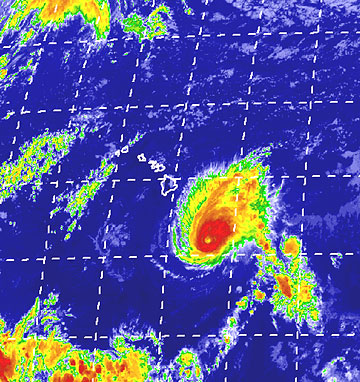
 HURRICANE TRACK COURTESY UNIVERSITY OF HAWAII The satellite map depicted Flossie's position as of about 9 p.m. yesterday. CLICK FOR LARGE |
|

The Category 3 hurricane will likely spare the rest of the island chain, forecasters say
Flossie, a dangerous hurricane moving south of the Hawaiian Islands, was expected to deliver a glancing wallop on the Big Island today, with up to 10 inches of rain in some areas and tropical storm-force winds.
On the island, Mayor Harry Kim declared a state of emergency, 11 shelters opened, and residents and tourists crowded stores to stock up on emergency supplies.
As of 11 p.m. yesterday, Flossie was flexing its maximum sustained winds of 115 mph that reached out 40 miles from the eye of the storm, while tropical storm-force winds extended 155 miles. It was 260 miles southeast of Hilo and 455 south-southeast, and moving west-northwest at about 15 mph.
The National Weather Service said Flossie's eye would likely pass about 90 miles south of South Point this afternoon. It was a Category 3 hurricane, meaning sustained winds of 111-130 mph, last night.
The Big Island was under a tropical storm warning and a hurricane watch. The most immediate effect of the storm was powerful and dangerous high surf that arrived last night. Southeast shores will see an increase in wave heights to 15 to 20 feet by this afternoon, forecasters said.
Gov. Linda Lingle signed a statewide emergency disaster proclamation for the state, which gives state Adjutant Gen. Robert Lee broad powers to activate members of the National Guard as needed in the case of an emergency.
The weather service said the storm is expected to largely spare the rest of the islands, which will likely see some rain, higher surf on south shores and gustier-than-normal winds. Still, forecasters and government officials urged residents to remain vigilant in case Flossie takes an unexpected move north.

