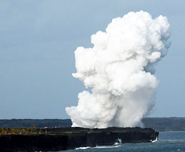
 JASON LUX / COURTESY OF NATIONAL PARK SERVICE Onlookers watched Thursday as 16 acres of the East Lae'apuki Delta at Hawaii Volcanoes National Park collapsed into the ocean, sending up large plumes of steam and debris. CLICK FOR LARGE |
|
16 acres of volcanoes coastline collapses into sea
Steam plumes shoot as high as a thousand feet, raining black sand on visitors miles away
About 40 visitors to Hawaii Volcanoes National Park witnessed an uncommon event when about 16 acres of coastline collapsed into the ocean.
The Thursday afternoon lava-bench collapse happened about two miles from the nearest public viewing spot. Park visitors saw steam and rocks shoot up from the collapse area as the coastline gave way over about four hours.
"It was very impressive. There were a lot of oohs and aahs," said park ranger Arnold Nakata.
Fist-size rocks were thrown as far as 450 feet inland, and one rock 14 inches in diameter was found 394 feet inland, officials said.
AFTER COURTESY OF NATIONAL PARK SERVICE The red circle shows the area where Thursday's lava-shelf collapse took a pronounced bite out of the East Lae'apuki Delta, producing an embayment. CLICK FOR LARGE |
|
HILO » Sixteen acres of coastline collapsed into the sea over four hours Thursday, repeatedly shooting clouds of steam full of rock fragments as high as a thousand feet in the air, Hawaiian Volcano Observatory officials said yesterday.
No one was injured at Hawaii Volcanoes National Park because the collapse zone was more than two miles from a park viewing site.
Park visitors, who totaled about 40 in the late afternoon, watched the collapses using spotting telescopes provided by the park, said ranger Arnold Nakata.
"It was very impressive. There were a lot of oohs and aahs," he said.
Each new segment of collapse produced a steam plume blackened by fragmented stone as hot rocks hit the sea.
While visitors watched, the rock fragments occasionally rained onto them as light showers of black sandy material, Nakata said.
The ranger said he began his workday at the end of Chain of Craters Road at about 2:35 p.m. An observatory statement said the first of the collapses happened at 2:45 p.m. It was small, without much of a steam plume, Nakata said. Later collapses grew in size, with the final event at 7:05 p.m.
There are three general areas on the coast where lava has been entering the sea off and on.
The site of the collapse is called East Lae'apuki. At 2.5 miles from the end of Chain of Craters Road, it is the closest to a public viewing area. No lava had been reaching the ocean there since mid-March, but lava that has stopped moving still retains intense heat for a long time.
When observatory personnel got to the area yesterday morning, they found a "scalloped" stretch of coastline about 1,450 feet long. The missing patches of ground had produced a bay extending 690 feet inland from the former shoreline, they said.
On the remaining shore, they found an "apron" of rock debris covering three acres.
Fist-size rocks had been thrown as far as 450 feet inland, and one rock 14 inches in diameter was found 394 feet inland, observatory officials said.
Portions of the "lava delta" -- new land built by recent flows -- did not collapse, but large new cracks crossing those areas could signal more catastrophic, future land losses, the observatory said.
East Lae'apuki was the site of two of the largest shoreline collapses since Kilauea began erupting in 1983.
In December 1996, 34 acres fell into the sea. In November 2005, 44 acres disappeared in segments over five hours. Nakata, who was working at the time of the 2005 event, recalled it as "quite phenomenal."

