
|
Kilauea
U.S.’s most
dangerous volcano?
|
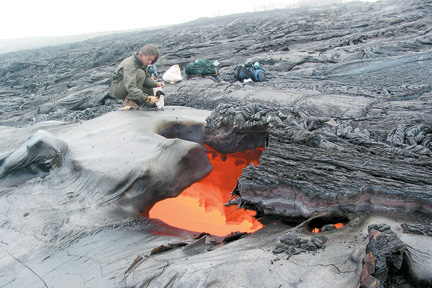
HILO » Kilauea is the most dangerous volcano in the nation, according to a new tabulation by the U.S. Geological Survey.
Volcanic threatsThe U.S. Geological Survey has assigned a "threat score" to 169 volcanoes in the United States and areas under U.S. control. Kilauea scored the highest in the nation.Here are the scores of five Hawaii volcanoes compared with three others erupting (E) or in "unrest" (U).
» Kilauea: 324 (E)
|
But Jim Kauahikaua, scientist in charge of the Hawaiian Volcano Ob- servatory, said people might be forgetting the explosive eruption of Kilauea in 1790 which killed 80 to 400 people in the army of Kona alii Keoua marching through the summit area.
In comparison, the 1980 explosive eruption of Mount St. Helens, the second-most dangerous U.S. volcano, killed 57 people.
The Geological Survey tabulated data on volcanoes as a first step toward creating a National Volcano Early Warning System. The plan was announced yesterday at the agency's headquarters in Reston, Va.
Kauahikaua said some data linkages already exist between the nation's five volcano observatories. The plan is to make all data from each of them fully available at all of the others, he said.
At least two people would be on duty 24 hours a day to give immediate warning of danger, he said.
Some of the greatest danger can come from clouds of volcanic ash shot high into the air, threatening any planes that accidentally fly into the cloud.
"We nearly lost a fully loaded Boeing 747 to volcanic ash cloud in Alaska in 1989," Capt. Ed Miller of the Airline Pilots Association said in a Geological Survey statement.
The need to give pilots warning within five minutes was met when Mount St. Helens erupted in 2004. But when Anatahan volcano erupted in the Northern Mariana Islands in 2003, authorities could not even confirm it for several hours.
The plan calls for gathering more data as well as sharing it more.
Kilauea received a top score for data monitoring with 29 global positioning stations, 24 seismographs and weekly gas monitoring, Kauahikaua said.
Starting in 2002, Mauna Loa has been showing signs of building to an eruption, but geologists still cannot say when. Mauna Loa data monitoring rated a score of only 3 out of a top score of 4 in the Geological Survey tabulation.
Mauna Loa just got 11 new global positioning stations for a total of 23, Kauahikaua said. It also has 23 seismometers, but permission from private landowners would be needed before more can be placed on the sides of the huge mountain.
And only three gas measurements were made on Mauna Loa last year using helicopter flights, compared with weekly ones on Kilauea.
pubs.usgs.gov/of/2005/1164
[News] [Business] [Features] [Sports] [Editorial] [Do It Electric!]
[Classified Ads] [Search] [Subscribe] [Info] [Letter to Editor]
[Feedback]