
|
TheBuzz Erika Engle |
Partners looking
to put Maui on a
Franko’s Guide Map
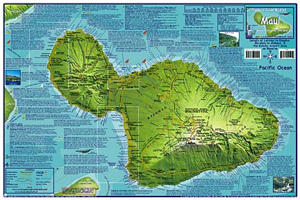
MAUI is about to get put on the map. Specifically, it will be put on a Franko's Guide Map, to be co-published by Frank Nielsen of California and Oahu-based Hawaiian Resources Co.
Nielsen and Peter Cannon, president of Hawaiian Resources, already publish a Maui map of recreational locations such as dive and surf spots, biking and hiking trails. The new map will be a more traditional visitor guide, in map form, printed on Teslin, a durable, waterproof, rip-proof plastic, as is Franko's wont.
The partners are looking for input on other types of things to see and do on Maui, but here's the catch -- the partners won't accept money for map listings.
"These maps are an honest effort to identify the most fun things to see and do when you come to an island and to identify the good operators," Cannon said.
The maps are going to press at the end of next month, so businesses hoping to be considered should quickly make a pitch to editor@frankosmaps.com.
Attraction and activity guide maps for Kauai, the Big Island and a dual Molokai and Lanai map will follow and the partners welcome input from those islands as well.
 |
"We really will consider anyone who throws out an idea," Cannon said.
The many types and subjects of maps Nielsen has produced are at www.frankosmaps.com. Only the Hawaii maps are a joint production between Cannon and Nielsen.
"All these maps are a work in progress. If we can improve them, we will," Cannon said. However, he's especially proud of his cartographer-partner Nielsen's work on the Waikiki portion of the Waikiki and Oahu Guide map. It bears clear instructions and freeway map insets, advising visitors on getting into and out of Waikiki. As for navigating around all the road work, visitors and kamaaina alike are on their own.
An avid mountain biker, Nielsen started making topographical maps of biking trails in California in 1992. As he did the work by hand and had a full-time job, the first two maps took a year to complete.
By 1999 Nielsen had begun using a computer to create more maps. Then, Nielsen accidentally crashed his mountain bike on a steep trail in California. His serious injuries required a long convalescence, during which he learned more skills and made more maps, including some of Hawaii.
In November 2000, he quit his civilian job certifying weapons testing systems for the Navy.
"The accident made me realize my mortality and that I can't stand being bored to death at my job," Nielsen said.
Nielsen and Cannon were introduced on Oahu following the Sept. 11 terrorist attacks, because Nielsen was unable to leave Honolulu for several days.
Cannon's company has been a publisher, wholesale distributor and importer of products from postcards to coffee table books since 1972 and through about two degrees of separation, they met.
The joint venture was discussed, the two shook hands and nearly 200,000 maps later the two split expenses and profits. "Hawaii is somewhere around half my total business (volume)," Cannon said.
The partners publish recreational maps in both folded and laminated formats for the islands, the guide map of Waikiki and Oahu and so-called "fish cards."
The laminated cards feature Hawaiian reef creatures divers are likely to encounter and are hole-punched for stringing onto a lanyard.
The recreational maps are big sellers at Aaron's Dive Shops in Kailua, according to Scott Shelley, manager of training and education.
"People come from the mainland and get disoriented (about where they are on the island) and Franko's maps are just really easy to read," he said.
The maps are also a helpful classroom tool and "we keep them in our vans as well. They list the Waikiki hotels and with so much construction, it's easy to navigate with," said Shelley.