KEN IGE / KIGE@ STARBULLETIN.COM
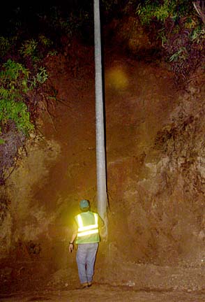
State engineer George Abcede looked over the section where some 40 cubic yards of earth came off the hillside on the northwest side of Castle Junction. The landslide occurred at 6:45 p.m. yesterday and closed one lane for about three hours.
Landslide hits
Windward area cited
for its high riskFive truckloads of dirt
are hauled away from
near Castle Junction
An area designated as one of the top five hazardous landslide sites along Oahu highways lived up to its billing last night.
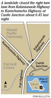
About five truckloads of mud and dirt came sliding down the mountainside next to the Kaneohe side of Castle Junction on Windward Oahu, according to state transportation officials. The 6:45 p.m. landslide closed the right-turn lane from Kalanianaole Highway onto Kamehameha Highway.
"It didn't land on anyone and it's mostly dirt, no rocks," said Department of Transportation spokesman Scott Ishikawa. "It's not like the landslide in Makapuu."
Crews determined early this morning that the area is "stabilized for now," Ishikawa said. He said they will spend the rest of the week evaluating the area to determine whether it should be "moved up on our priority list" for safety measures.
An Oct. 15 rock slide at Makapuu Point accelerated DOT plans for safety work at the site. Makapuu is ranked as the most hazardous area and has had $1.5 million of safety work already. However, state officials estimate as much as $17 million more is needed.
The next four areas that show the most risk for a landslide, according to a state study released last week, are Kamehameha Highway near Waimea Bay, Kamehameha Highway near Kahuku, Pali Highway on the Kailua-bound side of the roadway past Castle Junction, and the site of last night's slide .
Last night Ishikawa said workers estimated that bulldozers and trucks loaded up about 40 cubic yards of dirt from the landslide. The lane was reopened about 9:30 p.m. last night.
Kalanianaole Highway has the highest number of high-risk sites of any state roadway, the study said. Second is the Pali Highway with 12 and third is the H-1 freeway with 10 high-risk sites.
However, the rock fall hazard study showed that for the maximum number of high-danger spots in the fewest miles, the Pali Highway is the leader, with six in a mile-and-a-half stretch between Castle Junction and Kailua town.