DEAN SENSUI / DSENSUI@STARBULLETIN.COM
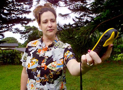
Beth Berry lets her Garmin eTrex GPS "initialize" to determine its location on the planet. She bought her GPS receiver specifically for the sport of geocaching.
WHILE THE KEIKI are out searching for plastic eggs filled with goodies this morning, adults now have a chance to take part in a treasure hunt of a different kind. Geocaching combines outdoor
What you need
activity with a treasure hunt using
the Global Positioning SystemBy Jason Genegabus
jason@starbulletin.comIt's called geocaching (pronounced "jee-oh-cash-ing") and is best described as a cross between outdoor activities such as orienteering and hiking with a good old-fashioned treasure hunt. And thanks to Global Positioning System technology and the community-building power of the Internet, geocaching is quickly becoming a favorite hobby for people around the world.
BASED ON TECHNOLOGY developed in the late '80s by the U.S. military, GPS receivers use signals received from 24 satellites that orbit about 11,000 miles above the earth to triangulate their position using high-frequency radio signals. No matter where you are on the planet, there are always at least three satellites within range of a GPS receiver.
While the military enjoyed full access to GPS technology for more than a decade, the civilian population initially had to make do with signals that were too imprecise to be used for more than a general estimate of an object's location. This was because the government maintained a policy of "Selective Availability." Ordinary citizens were given access to GPS technology that could only bring an individual within 300 feet or so of the desired target. Former President Bill Clinton dropped the policy in May 2000, making it possible for anyone to come within 30 feet of an object using a GPS receiver.
GEOCACHING IS A relatively simple activity to learn; all it takes to play is a GPS receiver and an Internet connection. You start by logging on to a Web site that maintains a database of latitude and longitude coordinates for caches hidden in various locations. One of the most popular Web sites is geocaching.com, with more than 49,000 active caches located in 170 countries. A Hawaii-based Web site also exists at www.lightfantastic.org/gps.
When I logged in to geocaching.com and entered my ZIP code, I didn't expect to see many listings for the state of Hawaii, so I was surprised to find more than 90 caches hidden within a 100-mile radius. Each one is listed on the Web site with corresponding levels of difficulty and terrain, along with a description of the cache and a few pointers from the person who hid it. Once you have the coordinates for the cache and a rough idea of the area where it's hidden, you're good to go.
DEAN SENSUI / DSENSUI@STARBULLETIN.COM
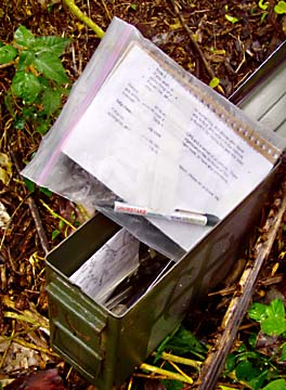
The ammo can stashed away at the "Strangled Palm Cache," above, is located at N 21° 18.793 W 157° 49.403. It contains various small items left there by other geocache hunters, as well as a log book and pen.
There are also different types of caches, to make the search more interesting. Traditional caches, normally housed in a military-style ammo box or Tupperware container, contain a few knickknacks such as foreign coins or other small objects of interest. It's a courtesy to leave something behind in exchange for what you find, so the next person has something to take away from the experience. Traditional caches also include a logbook allowing the finder to log his name and the date of discovery.
Virtual caches, on the other hand, don't have a physical presence at the coordinates listed on Web sites. Often these caches are landmarks that the person who "hid" them wants you to identify. Geocachers complete the find by answering a question about the landmark and e-mailing it to the cache's owner.
Multicaches require players to travel from location to location based on coordinates found at each one. Offset caches take the game one step further; coordinates for this type of cache are based on markers that may not have any meaning outside the geocachers' realm.
FOR MANOA RESIDENT Beth Berry, geocaching is an activity that provides an opportunity to get outside and explore different parts of the island. It also allows the marketing director at a local software company to spend more time with her husband, Basil.
When Berry and her husband moved to Hawaii in 2001, "our obsession ... was disc golf," she said. "But when we moved to Hawaii, we were sad to discover that there was no permanent disc golf course on Oahu.
"So we started looking for other outdoor things we could do together. ... We started hiking, snorkeling and driving around doing photo safaris. Then, one day, we added geocaching to our list."
Berry heard about geocaching.com from a friend and decided to check out the Web site for caches located on Oahu. "I searched within three miles of my house in Manoa, and almost 20 caches showed up," she said.
"I started reading about all of the hidden treasures in my own neighborhood, and I had to go find them," Berry continues. "The idea of being part of a worldwide game of hide-and-seek is exciting! You never know what treasure you're going to find in the cache, but more importantly, you never know what treasures you're going to find along the way."
During her adventures, Berry and her husband use a Garmin eTrex GPS receiver that they bought at the Sports Authority for about $100. "I wasn't sure if I would stick to the geocaching thing, so I just ... asked for the cheapest model they had.
"For geocaching (the eTrex) is just fine. It's pretty accurate and easy to use."
MY EXPERIENCE with geocaching wasn't as successful as I had hoped, but it did give me an understanding of the activity's appeal to different types of people. Earlier this week, I was out around the Ala Wai Canal, looking for a cache called "Life Is but a Dream."
Wandering around with a GPS receiver that a newsroom co-worker loaned me, I plugged in the coordinates listed on the Web site and began looking.
One of the first tips you'll get when starting out is to keep your head up while using the GPS receiver. Sometimes people, myself included, get too immersed in the receiver readings and end up walking into stationary objects. It took a near miss with a bicyclist and walking into a bench along the canal to get my attention off the GPS and back to my surroundings.
After 20 minutes of looking for the cache without any luck, I was getting frustrated. My GPS told me the direction I needed to head in was directly into the Ala Wai itself, and I didn't plan on taking a swim that afternoon. A few passing joggers gave me funny looks as I stood there like a character out of "Star Trek," waving my GPS around like a tricorder and cursing the fact that I couldn't find what was described as an "easy" cache.
A few minutes later, my patience wore out. I was happy to be outside in the sun with the tradewinds blowing, but not finding the cache was disappointing. Even with the high-tech help of GPS satellites above me, the game still calls for basic human instinct.
>> Stay on marked trails and off private property. Tips for new geocachers
>> Don't trample vegetation.
>> Don't bury caches -- digging holes is disruptive to the environment.
>> Keep a low profile -- don't be obvious when looking for or hiding the cache.
>> Cache in, trash out -- help protect the environment and remove any trash you see while geocaching.
BACK TO TOP |
What you need
>> GPS Receiver: These typically range in price from $100 to more than $1,000, and are necessary to lead geocachers to the listed coordinates of a cache.
DEAN SENSUI / DSENSUI@STARBULLETIN.COM
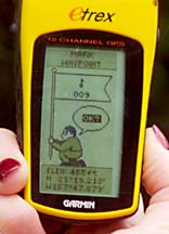
Beth Berry's GPS receiver gives her a readout of latitude and longitude.
>> Internet access: Web sites like geocaching.com, navicache.com and lightfantastic.org/gps are your source for cache locations. Web sites like mapquest.com can also help to narrow the search area before actually putting in the legwork.
>> Stuff to leave: Geocaching is like a treasure hunt of sorts -- many caches are big enough to hold a variety of items left by successive geocachers. While it doesn't have to be expensive, proper etiquette calls for "progressive exchange" upon the discovery of a cache. If you take something, leave something of equal or greater value behind for the next person who finds the cache. And don't forget to sign the logbook; part of the fun is seeing how many other people have made the same discovery, even if the entry is as simple as a date and the letters "TNLN (took nothing, left nothing)."
>> Compass/maps: Traditional navigational tools like a compass and topographical maps, while not entirely necessary, will help in planning your search for a cache. Some GPS receivers now have a compass built in, or they can be attached to a laptop computer with mapping software to provide real-time information and graphics.
Click for online
calendars and events.