DEAN SENSUI / DSENSUI@STARBULLETIN.COM
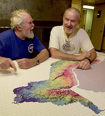
Michael Rhodes, left, of the University of Massachusetts, and Michael Garcia took a look at a computer-generated topographic map of the sea floor just offshore of South Point on the Big Island on Nov. 11.
Scientists have discovered 11 underwater radial vents (eruptive fissures) on the western flank of Mauna Loa, which they say present potential hazards from undersea volcanic explosions.
Scientists discover volcanic vents
in the sea where a Mauna Loa
eruption could occurObservatory retrieved from Loihi
By Helen Altonn
haltonn@starbulletin.comThe finding "has all kinds of implications," said Michael Garcia, a University of Hawaii geology-geophysics professor who was co-chief investigator on a recent expedition to Mauna Loa's undersea southwest rift zone.
"It tells us Mauna Loa volcanic activity is not restricted to the main rift zones and there is potential for hazards from explosions near sea level," Garcia said.
An explosive shallow-water eruption has the potential to generate a tsunami or spew hot ash onto people living in coastal areas, he said.
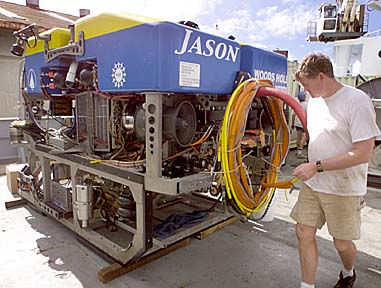
Researchers examined Mauna Loa's volcanic processes with the University of Washington vessel Thomas G. Thompson and Woods Hole Oceanographic Institution's new, sophisticated remotely operated submersible vehicle, Jason II.
DEAN SENSUI / DSENSUI@STARBULLETIN.COM
Bob McCabe, an engineer from the Woods Hole Oceanographic Institute, checked out the Jason submersible Monday and prepared it for unloading from the vessel Thomas G. Thompson.
Among the highlights of the venture, they surveyed a 1-mile-high undersea cliff -- the highest ever sampled in Hawaii formed by a volcanic landslide.
They said the survey of the cliff may reveal more than 400,000 years of Mauna Loa's eruptive history, probably half its lifetime.
Mauna Loa's only known underwater eruption occurred in 1877 from a radial vent in Kealakekua Bay, south of Kailua-Kona, Garcia said.
People on the shoreline and aboard a steamship going into Kailua-Kona reported seeing hot rocks floating to the surface, he said.
"Now we know there are at least 11 more of these submarine volcanoes," he said.
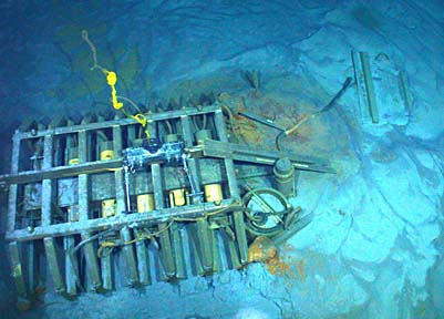
COURTESY OF FRED DUENNEBIER
The HUGO junction box almost ready to be retrieved from the ocean floor. The box monitored activity on Loihi Seamount.
Frank Trusdell, on the cruise from Volcano Observatory, pointed out that all the vents they mapped are outside the rift zone, occurring underwater all the way up the north and west points to the summit caldera.
He said this is a real concern -- "not that it's going to happen," he said, "but that is one of the possibilities for the next pending eruption."
"Normally, eruptions occur along the rift zone," he said. "Finding additional vents along the shoreline reinforces that not only the rift zone is involved, but the possibility of radial vents, as well."
An eruption occurring near the coastline will be more violent than typically occurs for Hawaiian volcanoes, Garcia said, noting the Diamond Head and Punchbowl eruptions were more explosive because they were near sea level with ocean water mixing with the hot rock.
Also on the cruise from UH were geology-geophysics professor Frederick Duennebier and graduate student Dorsey Wanless.
J. Michael Rhodes, a University of Massachusetts professor of geosciences who has studied Mauna Loa for 20 years, was co-principal investigator with Garcia.
DEAN SENSUI / DSENSUI@STARBULLETIN.COM
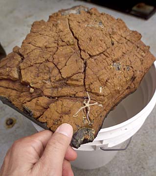
This layer of lava was retrieved from about a mile deep. On it is a brittle star. The scientists on board weren't able to exactly identify this biological specimen.
About 20 scientists from institutions in the United States, France, Canada and Australia participated in the undersea volcanic explorations from Oct. 25 to Nov. 1. The research program is sponsored by the National Science Foundation.
It was only the second cruise for Jason II. "We took it deeper than ever before -- 14,000 feet," Garcia said. It's designed to dive 21,325 feet.
The submersible collected 215 rock and sediment samples from Mauna Loa.
Rhodes said the rocks will go to his lab in Massachusetts, then samples will be distributed to the expedition members to study different aspects of the volcanic processes.
His group is looking for changes in composition of lava as the Pacific plate moves over the Hawaiian hot spot where the islands were born and Loihi, the newest potential island, is growing.
"If we can get a long section in Mauna Loa going back in time, maybe as much as 400,000 years, we can map what's happened to Mauna Loa as it goes over the mantle plume," Rhodes said.
Pointing to the mile-high undersea cliff on the scientists' new map of the southwest rift zone, he said: "The beauty of this is it's like taking a slice from a cake. We can look back at the early history of volcano."
Garcia is interested in volcanic glasses and minerals. Other scientists will date the rocks, study trace elements and isotopic composition of lavas.
Trusdell, studying Mauna Loa on land and under water, said the volcano is as large as all the Hawaiian islands put together.
He said Woods Hole's Jason expedition team, led by Matt Heintz, was a tremendous resource in documenting the ocean floor to compare with previous surveys.
The scientists produced the first detailed map of the entire 23-mile-long underwater section of Mauna Loa's southwest rift, covering about 800 square miles to a depth of 2.8 miles.
"The great thing about this ship is it allowed us to do surveying in shallow portions of Mauna Loa which hadn't really been surveyed properly. ... That is how we were able to find many of these volcanoes offshore, the radial vents," Garcia said.
Shallow coral deposits on the flanks of the volcano were another surprise, "which is an indication of the sinking of the volcano," Garcia said. Coral dating will be done to determine when the volcano sank, he said.
The Jason team operated from a control van that was filled with people looking at the TV screens and videos during exciting activities, such as recovery of an observatory junction box from Loihi, Garcia said. It was a major feat to find it, hook everything up and cut the cable, he said.
To prevent surface motion for Jason, it was tethered to the Medea, another submersible vehicle connected to the ship by cable.
Heintz said Jason II, following an earlier Jason, has a lot more capability, more payload, better manipulators, sonar, maneuverability and control systems, and more bandwidth for video. It has two arms to grab things and five cameras with capacity for 10.
BACK TO TOP
|
An observatory placed at the summit of undersea volcano Loihi five years ago to monitor its activity has been recovered and eventually will be returned there. Data monitoring device
recovered from volcanoBy Helen Altonn
haltonn@starbulletin.comFrederick Duennebier, University of Hawaii geology-geophysics professor, developed the Hawaii Undersea Geo-observatory, or HUGO.
He was on the University of Washington research vessel Thomas Thompson recently when HUGO was found with Jason II, a remotely operated vehicle belonging to the Woods Hole Oceanographic Institution.
"It looked very lonely down there," he said. "At first, it liked like a shipwreck with ribs half buried. It's in excellent shape. All the tubes are intact. I don't have any doubt it would still be working if the cable had worked."
The cable, between Loihi and the Big Island, went out in 1998, effectively shutting down the recording instruments.
Duennebier expects to put HUGO back on Loihi in a few years after improving it with new technology and protecting the cable with steel armor so it won't be broken by lava flows.
Matt Heintz, leader of the Woods Hole Jason expedition team, said the HUGO recovery operation took about eight hours.
"We had trouble finding it," he said. And once they did, they had to guess where the buried cable was, he said.
The ROV dug for the cable, pulled it up and cut it to retrieve the observatory.
Duennebier used the first Jason on the Thompson in 1999 to put deep-sea seismic instruments on an old telephone cable midway between Hawaii and California.
He receives signals from the Hawaii 2 Observatory in his office on the Manoa campus via the AT&T station at Makaha.
Duennebier also received a $2 million grant to develop an ocean-bottom observatory for the Hawaii Ocean Time-series. The HOT program began in 1988 at an ocean site called Station Aloha about 60 miles north of Oahu.
Oceanographers have been investigating the marine environment there every month for 14 years, Duennebier said.
He is already working on the new observatory for physical oceanography, he said.
Most of the current grant will be used to connect a decommissioned Australia-New Zealand-Canada underwater cable to the Makaha station so that UH can receive the data by phone line, he said.