
|
Hurricane readiness As meteorologists look to a moderate El Nino season, which would mean increased tropical storm and hurricane activity, state and county civil defense officials once again brace for the start of the hurricane season which runs from June through November.
test starts May 10
Officials will take part in
the annual exercise to test
the emergency response systemBy Gregg K. Kakesako
gkakesako@starbulletin.com"One reason we prepare," said Tom Heffner, National Weather Service meteorologist, "is because of past events and the knowledge of what past events can do."
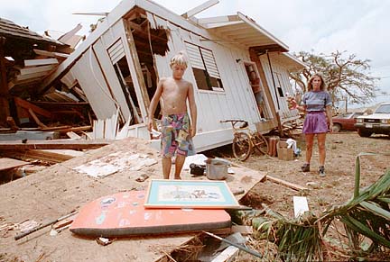
Referring to the island's last biggest hurricane -- Iniki --which struck in 1992, Heffner said that storm resulted in $2 billion in damages, mainly on Kauai.
To prepare for this year's hurricane season, federal, state and county officials will again participate in an annual hurricane preparedness exercise dubbed "Makani Pahili 2002" -- which will run from May 10-17.
The annual one-week hurricane readiness exercise is designed to test certain facets of Hawaii's emergency response and recovery and involves various military services.
Heffner noted that the majority of the storms that threaten the Hawaiian Islands originate in the eastern Pacific.
The triple threat for all islands from a hurricane is storm surge and high surf, high winds whose force will be greatly magnified by the island's terrain and heavy rains and flash flooding.
"Historically," Heffner said, "the impact of storm surges has been the biggest killer."
Coastal areas are always at risk and people living there should leave before a surge arrives.
The Makani Pahili scenario will call for east and southern shores to be at the greatest risk with combined surge and surf producing water up to eight feet above sea level.
That would mean structures within 300 yards of the coast would be affected -- not unlikely during a real bad storm.
Planners will begin tracking a simulated hurricane as soon as it crosses 140 degree longitude, Heffner said, noting that the majority of the storms that threaten the Hawaiian Islands originate in the eastern Pacific.
Forecasters have already predicted more tropical cyclones, including tropical depressions, storms and the worst being hurricanes, during an El Nino which means "boy child" in Spanish.
The phenomenon is associated with abnormal warming of eastern Pacific waters that upsets wind and rainfall patterns and causes storms, droughts and crop failures around the world.
When the central Pacific last experienced an El Nino in 1992 there were three tropical storms, five tropical depressions and three hurricanes, including Iniki.
Forecasters already have a name for the season's first storm -- Alika.