
[ STUFFS ]
WAT DAT?

|
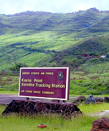
Get about as far away from everything as you can get on Oahu -- without running out of paved road -- and you wind up at Yokohama Bay, north of Makua Valley. Here, on the leading edge of the Waianaes, things seem fairly elemental. Military facility at Kaena Point
keeps sharp eye on the skies
By Burl Burlingame
bburlingame@starbulletin.comExcept for what appears to be a resort complex nestled up on the hillside.
We're looking at Kaena Point Satellite Tracking Station, an Air Force facility that does various things but basically keeps track of stuff hurtling through the sky.
It's part of a remote-sensing network that includes New Boston, N.H.; Colorado Springs, Colo.; Thule, Greenland; and Diego Garcia in the Indian Ocean.
The orbits of Department of Defense satellites are controlled by the Air Force Satellite Control Network, based in Sunnyvale, Calif., at a facility later named Onizuka Air Base in honor of the Hawaii astronaut. That property is currently being disposed, and some operations are handled by the Consolidated Space Operations Center in Falcon Air Force Base, Colo.
The Kaena Point station is also involved in missile-defense studies, and the civilian contractor is ITT Industries.
Why Kaena Point? Because the air is clear of electronic interference for the Air Force's sensitive instrumentation.
Curious about something you've seen or heard? Write "Wat Dat?" 7 Waterfront Plaza, Suite 210, Honolulu 96813; or e-mail watdat@starbulletin.com
PLATE LUNCH TAKES CENTER STAGE

|
Click for online
calendars and events.
Send WatDat? questions, stories
or any other story ideas or comments to:
Features, Honolulu Star-Bulletin, P.O. Box 3080,
Honolulu, HI 96802 or send a fax to 523-8509
or E-mail to features@starbulletin.com.
Please include your phone number.