
[ SUNDAY TRAVEL ]
Hiking in the Rubies ONCE a year I have the opportunity to escape the barrage of e-mail, news, school, work and finances with a group of buddies from Pasadena (Calif.) High School who have continued to keep in touch and reunite -- not in any bar or Las Vegas casino, but in the wilderness.
An adventure into Nevada's rough
country renders changes both
in the hikers and worldBy Chris Sunoo
Special to the Star-BulletinThe original crew of seven has grown to include comrades from Idaho, Utah, California, New Zealand and Hawaii. Our adventures have included floats down the Rogue River in Oregon and hikes through the Zion Narrows in Utah, Jasper National Park in Alberta, and the rain forests of Costa Rica.
During these trips, the only things that I miss are the comforts of family, a soft bed and the warmth of Hawaii mornings. But it is during trips like these that we can gain perspective about the world. While gazing at the Milky Way and scanning the skies for shooting stars, we've wondered what the world was like when walking over the mountains was a way of life.
The 2001 trip, set for Sept. 10 to 15, was centered around friend John's plans to participate in a friend's wedding party. It turns out that John bailed out a week before the trip. I'm still not sure if it was his memory of last year's trip -- he ended up being helicoptered out of the wilderness, which is another story entirely -- or a legitimate business excuse that changed his mind. That left a crew of eight for the trip to the Ruby Mountains outside of Elko, Nev.
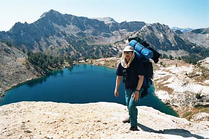
The Ruby Mountains are a beautiful, glacially etched range. According to the U.S. Forestry Service, geologists estimate this ridge -- 60 miles long by 10 to 12 miles wide -- emerged about 20 million years ago when the earth's crust folded and broke several times. Alpine glaciers during the Ice Age scoured the northern end of the Rubies. Lamoille Canyon, an unshaped canyon in the heart of the Rubies, is known as "Nevada's Yosemite" because of the hanging valleys, towering peaks and year-round snowfields above it.The Rubies encompass 10 peaks above 10,000 feet, including the 11,387-foot Ruby Dome, and more than two dozen alpine lakes.
The Rubies got their name during the Gold Rush days of the 1800s, when the U.S. Army came to Nevada to help early pioneers find routes to California. Soldiers began panning for gold in the range's stream beds. They found garnets, which they mistook for rubies.
The mountains are much less traveled than the Rockies or Sierras, and I found the altitude more tolerable than the other ranges for those who live at sea level. The fishing is awesome, the scenery gorgeous and the terrain challenging enough for the most ardent backpacker. Weather is always unpredictable in the high country, so be prepared for heat (bring sunscreen), rain and/or snow.
Our planning usually starts a year in advance, but procrastination and lack of commitment usually keeps it from being completed until a few months before the trip.
Three of the crew originated in Salt Lake City. Four more of us flew into Salt Lake. From there we drove to Elko. Another friend drove from Twin Falls, Idaho, to Elko and met us at Stockman's Hotel and Casino. We spent the night at Stockman's, making a few bucks playing craps before our hike the next day.
The hike is a 43-mile trek from one end to the other. We arranged for a car to be left at the ending point. One end of the trip boasts a forest of aspens, their leaves changing into fall's colors. The other end of the trail was high desert, beautiful in its own right with low chaparral and dry, parched land. We chose the route least traveled and went from South to North.
The hike started at Harrison Pass -- a desert complete with sheep and horse bones and skeletons of small mammals -- after conserving some time and energy by driving about four miles on a jeep road. About six miles in, we made it over our first pass at about 8,400 feet and continued about four miles to camp at Smith Creek, at 7,900 feet.
On Day 2, Sept. 11, we headed for Overland Lake. This required "stair stepping" up and down three passes, the highest at 10,250 feet. It was a welcome sight to see the lake at midday. Once there, we settled in and easily caught several brook trout. We settled around the campfire and talked of how few people have the opportunity to experience the wilderness and the camaraderie of old friends.
It was a clear night, shooting stars and satellites crossing the Milky Way. Kyle mused, "One day we're gonna walk out of here and a nuclear war is gonna have already been over."
The night was a windy one. Lying in my tent, I could hear the wind come over the ridge and whip through the camp. Some had to come out of their tents to secure their tent flys. You could feel the dirt and loose foliage hitting the side of the tent. My tent has held up in rain and sleet and snow for 14 years, and didn't let me down that night.
Day 3 was one we had been warned would provide us no water for 10 to 12 miles so we packed four quarts each. Remember that a gallon of water weighs eight pounds, adding to the 50-plus pounds of stuff we had in our packs.
OUR MAPS indicated we'd cross a couple of passes, but by the time we reached Wines Peak at 10,893 feet after four passes and stair stepping for six hours through near-freezing rain and fog, we wondered if the peak was named after a person or how you felt when you reached it. We renamed the location "Whiner's Peak."
We finally settled down at Furlong Creek between Favre and Furlong lakes. We just couldn't go any further. Swaney, a high altitude marathoner, had hiked past this point, but Kyle wasn't in sight, having held up the rear for this leg of the trek, so we decided to settle in for the evening. We would have to catch up to Swaney the next day. Up to this point we hadn't seen another soul on the trail.
On Day 4, Sept. 13, we headed out toward Favre Lake in search of Swaney. A couple of miles into the day's hike we heard a whistle and spotted Swaney in the landscape below. Before we turned to make our way to Favre Lake, we ran into a couple from upstate New York. We gave them rough directions to Furlong Lake, exchanged pleasantries and they asked us if we wanted to hear some news. We responded, "Sure."
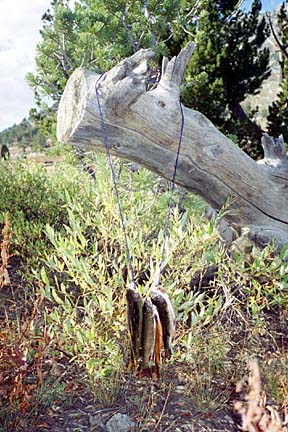
Needless to say, the news of Sept. 11 was numbing. We were left with someone else's picture of what had happened that day and only speculation as to the future of the world as we knew it. A sleepless night was inevitable. The rest of the day was spectacular, though, with clear skies and unparalleled fishing. Brad and I caught eight brook trout, cooked them lightly over a fire and pupus were served. Talk around the fire was much less serious that night.
Day 5, Sept. 14, we headed to Liberty Lake -- with its spectacular indigo water and the sun shimmering off its surface -- and finally out to the car waiting at the trail head. Brad, Marc and Wayne headed out to get the other two vehicles that would bring us back to civilization. We couldn't wait for our ride to the crap tables, a shower and some real food.
We always feel we leave the world and return better for our adventure. The world is always different when we return, but this time it was not only different for us, but everyone else as well.
Chris Sunoo has been a Hawaii resident for 16 years.