
Warm and dry Two scientists are predicting dry conditions here again this winter, although they disagree about the cause.
winter predicted
for Hawaii
Prolonged drought conditions
suggest a wider climate pattern,
2 researchers reportBy Helen Altonn
haltonn@starbulletin.comUniversity of Hawaii oceanographer Roger Lukas believes a weak to moderate El Nino will occur based on a number of factors he has observed through years of research. "The tendency, I believe, will be toward continued warming through the fall and into the winter, where we will then have a peak in equatorial sea surface temperatures," he said.
Bill Patzert, a UH graduate now at the Jet Propulsion Laboratory, suggests that the Pacific Decadal Oscillation "could act as an El Nino repellent" and pick up where La Nina left off.
Either way, the result would be the same for Hawaii: a warm, dry winter.
The Pacific Decadal Oscillation is a widespread pattern of sea-surface temperatures in the Pacific Ocean that has opposite warm and cool cycles. University of Washington scientists discovered it in 1996 while doing research on fish population fluctuations.
Patzert said, "People are still scratching their heads about all this because PDOs are new to us."
When it is in its cold phase, which it is now, it persists for five to 10 years, Lukas said, noting the 1997-98 El Nino resulted in a pronounced drought and dry winter that did not go away. "At that time, that was kind of hard to understand, but now it has become clear that the persistent drought is associated with the Pacific Decadal Oscillation, a 10- to 20-year phenomenon."
Problems related to the phenomenon are far more serious than one winter of stormy weather or dry conditions with an El Nino, Lukas said.
"With a Pacific Decadal Oscillation, we're looking at four or five years, maybe more. ... When you have a number of dry years strung together, there are much more serious impacts. Farmers on the Big Island can tell you about that."
If Lukas' forecast of an El Nino this winter is correct, he said, it will tend to reinforce the dry conditions associated with a Pacific Decadal Oscillation.
El Ninos occur when warm waters in the western Pacific drift eastward. La Ninas are characterized by colder-than-normal waters in the tropical Pacific.
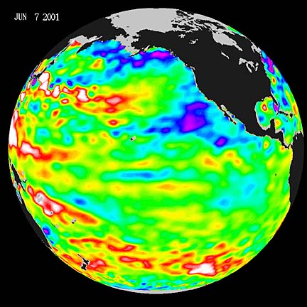
Reporting on El Nino for NASA, Patzert said, "The latest sea surface temperature data from the U.S.-French TOPEX/Poseidon satellite show that while La Nina has subsided, there are no signs of a resurgent El Nino."
A negative Pacific Decadal Oscillations cycle, seeming like an El Nino repellent, is when cooler surface waters in the eastern Pacific are surrounded by warmer waters in the north, west and south.
In that phase, Patzert said, sea surface temperatures resemble those of La Nina, resulting in dry conditions in many parts of North America. "It looks like we're heading for more of the same hot, dry weather."
Lukas said his forecast of an El Nino is based on a variety of factors he has followed since 1982 that seem to be consistent from one El Nino event to another.
They include westerly winds in the equatorial Pacific, stronger monsoon forces on the Pacific Ocean and high, wind-generated Kelvin waves (a bulge of warm water) across the entire Pacific to the region off Peru and Central America.
Also, he said, the boundary between warm surface water and cold deep water is deeper than normal for this time of year, and currents in the western and central Pacific frequently have been eastward near the surface.
Those currents tend to carry warm water from the Western Pacific to the Central Pacific, and the deeper boundary tends to reduce the effect of equatorial upwelling, which tends to keep the equator cold, he said.
"So all of these factors together tend to point toward warming of the sea surface temperature in the central Pacific. We have seen a pronounced warming of the eastern and central and even western equatorial Pacific over the last half of this year. But because we were in a La Nina situation, that warming has returned us to just slightly warmer than normal," Lukas said.
He believes the western winds, easterly currents and waves eliminated the La Nina that developed after the 1997-98 El Nino.