Advertisement - Click to support our sponsors.

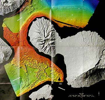
Maps reveal Underwater landslides, coral reefs and sediment patterns -- even remnants of an old hospital -- show up clearly in the first detailed maps of the sea floor around the Hawaiian Islands.
Hawaii seabed
New techniques show
How to view or purchase them
underwater canyons, submerged
reefs and debris from landslidesBy Helen Altonn
Star-Bulletin"It's the first time any of the sea floor has been mapped in this kind of detail, ever," James Gardner said by telephone from the U.S. Geological Survey in Menlo Park, Calif.
Gardner and a team mapped areas between the islands with the latest generation of high-resolution multibeam systems.
The University of Hawaii's new SWATH (small waterplane-area twin-hull) research vessel, under construction in Florida, will have two systems by the same manufacturer, said Margo Edwards, director of the university's Mapping Research Group.
One will be higher resolution for use in shallow water and the other will be lower resolution for deeper water, she said.
Gardner said, "Any time you map any area at much higher resolution than before, it's like putting very good glasses on somebody myopic.
"What we had was a very fuzzy, distorted view of the sea floor. When you put on glasses, everything jumps out at you. We knew we were going to be surprised because we had never seen the sea floor in Hawaii."
Edwards spotted blocks of concrete from an old hospital dumped in deep water off Oahu, presumably to attract fish. "You could really see big blocks of concrete on the south flanks of Oahu."
Underwater landslides also are shown in great detail, she said.
Gregory Moore, UH geology and geophysics professor, said the maps provide "really good details of things like reef platforms that used to be at sea level and have now subsided."
They show the surface structure of big landslide deposits and details of submarine canyons that cut down from sea level into deeper water, he said.
He said the Geological Survey mapping system "gives us a high-resolution connection between surface topography and what we can map with other systems on the deep floor."
The system on the UH's new ship will be hull-mounted, he said, while the Geological Survey system is portable and transported between ships. "On this survey, they used a really small boat, able to get into 10-meter (33-foot) depths."
Gardner said he spent about six weeks at sea in early 1998 mapping offshore dump sites around Hawaii for the Corps of Engineers. The Environmental Protection Agency requires that this be done every few years and the corps had no way to do it, he said.
It cost about $1.2 million, he said, "but when you think about it, it's not very expensive because it's good for a huge audience. It's not so much what we learned, but we provided base maps for all observers ... all the studies that are going to go on for the areas we've mapped."
The maps are useful not only for scientists but for the ocean recreation industry and people who use the ocean for subsistence, said Charles "Chip" Fletcher, UH geology and geophysics professor.
"You can't really understand any natural resource until you know its extent and its variability and diversity, and where it occurs and where it does not occur," he said. "Without maps, it takes years and years of experimental forays into the ocean before you learn where the different types of bottom resources can be found in the subsistence and ocean recreation area."
The maps enable policymaking and conservation agencies, such as the state Department of Land and Natural Resources, to develop site-specific policies, Fletcher said.
The USGS report is entitled: "Bathymetry and selected perspective views of sea floor north and west of Maui, Hawaii."
The seabed maps are available for inspection in Honolulu at 677 Ala Moana Blvd., Suite 415, as well as at USGS libraries in Menlo Park, Denver, Colo., and Reston, Va., and at USGS Earth Science Information Centers in Menlo Park and Salt Lake City, Utah. To learn more
Copies may be purchased from the USGS Branch of Information Services, Box 25286, Denver, Colo., 80225-0286 (telephone 1-888-ASK-USGS). The price is $4 per copy, plus $5 for shipping and handling per order.
Specify the report number, "WRIR OO-4046," and include a check or money order payable to the Department of the Interior, USGS.
For more information, see http://walrus.wr.usgs.gov or http://www.usgs.gov/.