Advertisement - Click to support our sponsors.

Daniel heading
toward islands
It might be downgraded
Star-Bulletin staff
to a tropical storm by the
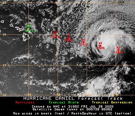
time it reaches this areaHurricane Daniel continued to head toward Hawaii today but is expected to weaken to a tropical storm as it nears the islands.
It was about 1,000 miles a little south of east of Hilo at 8 a.m. and weakening, according to Bob Larsen, National Weather Service lead forecaster.
The hurricane was traveling close to 20 mph with maximum sustained winds of 115 mph and stronger gusts.
If it doesn't change course -- a likely possibility -- it might be about 300 miles from the Big Island Monday, Larsen said.
Even if the storm moves more to the west or south, the Big Island probably will get some rain and clouds from the fringes of it, he said.
"Whether or not it gets winds will depend on the track."
The National Hurricane Center has been tracking Daniel, but the Honolulu forecast center expected to take over that job today as the storm moved into into the Hawaii region.
A tropical storm can have maximum sustained winds up to 73 mph.
NOAA information on Daniel
Central Pacific Hurricane Center
UH Storm tracker
