

Three-day forecast
Tomorrow: Partly sunny; gusty breezy, windward showers. Wind E at 15-25 mph. 61/80
Surf forecast
Marine forecast
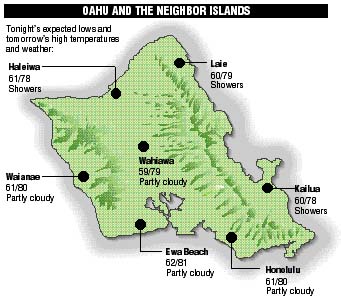
Neighbor island FORECASTS
Temperatures listed are tonight's expected lows and tomorrow's highs:
Kilauea
Lava continues flowing actively into the ocean, and others flows are spreading on the surface inland from there.
Temperature
At Honolulu Airport:High yesterday -- 81
Low yesterday -- 72
Record high -- 86 (1987)
Record low -- 57 (1993)
Normal high -- 80
Normal low -- 66
Rain
Humidity -- 74%
Yesterday -- 0.00"
Month-to-date -- 0.01"
Normal month-to-date -- 0.63"
Year-to-date -- 0.01"
Normal year-to-date -- 0.63"
Sun and Moon
Sunset tonight -- 6:04 p.m.
Sunrise tomorrow -- 7:11 a.m.
Moonset tonight -- 6:22 p.m.
Moonrise tomorrow -- 7:56 a.m.Phases of the moon:
New	Jan 6	First	Jan 14
Full	Jan 20	Last	Jan 27
UV index
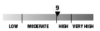
The ultraviolet index rates your risk to sun exposure. The higher the number, the greater the risk. Listed is tomorrow's forecast: "15 is the greatest risk".
Tides
Three-day forecast for Honolulu:
DAY	HIGH			LOW
Fri.	4:47a.m.	2.3 ft.	-----
	4:35p.m.	0.7 ft.	12:03p.m.	0.3 ft.

Sat.	5:20a.m.	2.2 ft.	-----
	5:18p.m.	0.7 ft.	12:37p.m.	0.2 ft.

Sun.	5:54a.m.	2.2 ft.	-----
	6:07p.m.	0.8 ft.	1:13p.m.	0.2 ft.
Elsewhere throughout the state tomorrow:
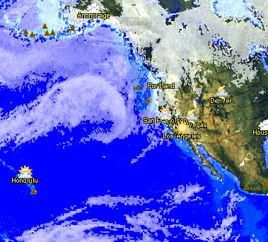
PLACE		HIGH	LOW	HIGH	LOW
Haleiwa		3:45	9:58	3:33	7:48
Hilo		3:43	11:04	3:31	8:54
Kailua-Kona	4:21	11:41	4:09	9:31
Kaneohe		3:01	10:45	2:49	8:35
Kawaihae	4:43	-----	4:31	12:00
Kealakekua	4:31	11:51	4:19	9:41
Nawiliwili	4:20	11:38	4:08	9:28
Waianae		5:07	-----	4:55	12:21
Waimanalo	3:32	10:54	3:20	8:44
THE PACIFIC
Hawaiian Volcano Observatory