

Three-day forecast
Tomorrow: Sunshine and pleasant; a few windward showers. Wind E at 10-20 mph. 68/80
Surf forecast
Marine forecast
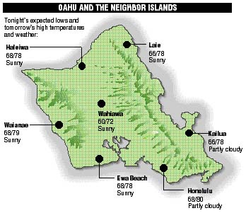
Neighbor island forecasts
Temperatures listed are tonight's expected lows and tomorrow's highs:
Kilauea
Eruption of Kilauea continues. Lava is flowing down the side of the mountain to the sea.
Temperature
At Honolulu Airport:High yesterday -- 81
Low yesterday -- 65
Record high -- 87 (1995)
Record low -- 57 (1989)
Normal high -- 81
Normal low -- 67
Rain
Humidity -- 82%
Yesterday -- 0.00"
Month-to-date -- 1.58"
Normal month-to-date -- 2.01"
Year-to-date -- 10.94"
Normal year-to-date -- 20.23"
Sun and Moon
Sunset tonight -- 5:53 p.m.
Sunrise tomorrow -- 7:03 a.m.
Moonset tonight -- 2:43 a.m.
Moonrise tomorrow -- 3:34 p.m.Phases of the moon:
Full	Dec 22	Last	Dec 29
New	Jan 6	First	Jan 14
UV index
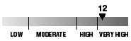
The ultraviolet index rates your risk to sun exposure. The higher the number, the greater the risk. Listed is tomorrow's forecast: "15 is the greatest risk".
Tides
Three-day forecast for Honolulu:
DAY	HIGH			LOW
Sun.	1:49a.m.	2.0 ft.	8:24a.m.	0.5 ft.
	1:07p.m.	1.1 ft.	7:15p.m.	-0.2 ft.

Mon.	2:33a.m.	2.3 ft.	9:23a.m.	0.3 ft.
	2:01p.m.	1.0 ft.	7:55p.m.	-0.3 ft.

Tues.	3:16a.m.	2.5 ft.	10:17a.m.	0.2 ft.
	2:55p.m.	0.9 ft.	8:37p.m.	-0.3 ft.
PLACE HIGH LOW HIGH LOW Haleiwa 12:47 6:19 12:05 5:10 Hilo 12:45 7:25 12:03 6:16 Kailua-Kona 1:23 8:02 12:41 6:53 Kaneohe 12:03 7:06 ----- 5:57 Kawaihae 1:45 8:21 1:03 7:12 Kealakekua 1:33 8:12 12:51 7:03 Nawiliwili 1:22 7:59 12:40 6:50 Waianae 2:09 8:42 1:27 7:33 Waimanalo 12:34 7:15 ----- 6:06THE PACIFIC
Volcanoes Observatory