

Three-day forecast
Tomorrow: Mostly sunny with a windward shower. Wind E at 10-20 mph. 69/88
Surf forecast
Marine forecast
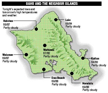
Neighbor island forecasts
Temperatures listed are tonight's expected lows and tomorrow's highs:
Kilauea
Eruption of Kilauea continues. Lava is flowing in a remote area of the park sluggishly to the sea.
Temperature
At Honolulu Airport:High yesterday -- 87
Low yesterday -- 75
Record high -- 91 (1995)
Record low -- 65 (1955)
Normal high -- 87
Normal low -- 72
Rain
Humidity -- 68%
Yesterday -- trace
Month-to-date -- 0.05"
Normal month-to-date -- 0.65"
Year-to-date -- 7.19"
Normal year-to-date -- 13.59"
Sun and Moon
Sunset tonight -- 6:10 p.m.
Sunrise tomorrow -- 6:26 a.m.
Moonset tonight -- 8:44 p.m.
Moonrise tomorrow -- 10:03 a.m.Phases of the moon:
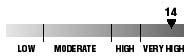
First	Oct 17	Full	Oct 24
Last	Oct 31	New	Nov 7
UV index
The ultraviolet index rates your risk to sun exposure. The higher the number, the greater the risk. Listed is tomorrow's forecast: "15 is the greatest risk".
Tides
Three-day forecast for Honolulu:
DAY	HIGH			LOW
Wed.	6:30a.m.	1.9 ft.	-----
	6:15p.m.	1.0 ft.	1:35p.m.	0.6 ft.

Thurs.	7:19a.m.	1.9 ft.	-----
	7:09p.m.	0.8 ft.	2:53p.m.	0.6 ft.

Fri.	8:17a.m.	1.8 ft.	12:21a.m.	0.5 ft.
	8:39p.m.	0.8 ft.	4:22p.m.	0.6 ft.
Elsewhere throughout the state tomorrow:
PLACE		HIGH	LOW	HIGH	LOW
Haleiwa		5:28	11:30	5:13	9:41
Hilo		5:26	-----	5:11	12:36
Kailua-Kona	6:04	-----	5:49	1:13
Kaneohe		4:44	-----	4:29	12:17
Kawaihae	6:26	-----	6:11	1:32
Kealakekua	6:14	-----	5:59	1:23
Nawiliwili	6:03	-----	5:48	1:10
Waianae		8:50	1:35	8:35	3:53
Waimanalo	5:15	-----	5:00	12:26
THE PACIFIC
Volcanoes Observatory