

Three-day forecast
Tomorrow: Mostly sunny with a windward shower or two. Wind E at 10-20 mph. 69/88
Surf forecast
Marine forecast
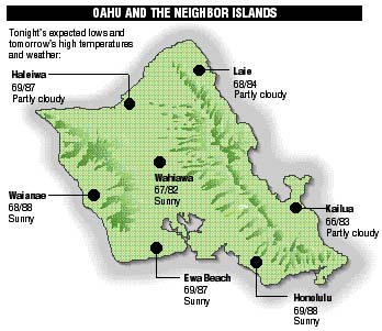
Neighbor island forecasts
Temperatures listed are tonight's expected lows and tomorrow's highs:
Kilauea
A lava pond continues to form in an upland area not visible from public viewing sites.
Temperature
At Honolulu Airport:High yesterday -- 87
Low yesterday -- 71
Record high -- 93 (1993)
Record low -- 67 (1981)
Normal high -- 88
Normal low -- 73
Rain
Humidity -- 71%
Yesterday -- 0.00"
Month-to-date -- 0.20"
Normal month-to-date -- 0.73"
Year-to-date -- 7.14"
Normal year-to-date -- 12.89"
Sun and Moon
Sunset tonight -- 6:21 p.m.
Sunrise tomorrow -- 6:23 a.m.
Moonset tonight -- 11:45 a.m.
Moonrise tomorrow -- nonePhases of the moon:
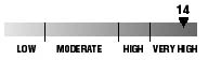
Last	Oct 1	New	Oct 9
First	Oct 17	Full	Oct 24
UV index
The ultraviolet index rates your risk to sun exposure. The higher the number, the greater the risk. Listed is tomorrow's forecast: "15 is the greatest risk".
Tides
Three-day forecast for Honolulu:
DAY	HIGH			LOW
Fri.	9:42a.m.	2.1 ft.	1:52a.m.	0.4 ft.
	10:10p.m.	0.8 ft.	5:29p.m.	0.5 ft.

Sat.	10:55a.m.	2.1 ft.	3:09a.m.	0.4 ft.
	11:46p.m.	0.9 ft.	6:33p.m.	0.4 ft.

Sun.	11:58a.m.	2.1 ft.	4:36a.m.	0.5 ft.
	-----		7:18p.m.	0.3 ft.
Elsewhere throughout the state tomorrow:
PLACE		HIGH	LOW	HIGH	LOW
Haleiwa		8:40	-----	9:08	3:24
Hilo		8:38	12:53	9:06	4:30
Kailua-Kona	9:16	1:30	9:44	5:07
Kaneohe		7:56	12:34	8:24	4:11
Kawaihae	9:38	1:49	10:06	5:26
Kealakekua	9:26	1:40	9:54	5:17
Nawiliwili	9:15	1:27	9:43	5:04
Waianae		-----	4:10	12:02	7:47
Waimanalo	8:27	12:43	8:55	4:20
THE PACIFIC
Volcanoes Observatory