

Three-day forecast
Tomorrow: Sunny to partly cloudy; a windward shower or two. Wind E at 10-20 mph. 69/88
Surf forecast
Marine forecast
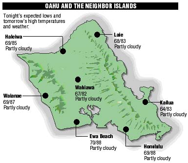
Neighbor Island forecasts
Temperatures listed are tonight's expected lows and tomorrow's highs:
Kilauea
The eruption of Kilauea is in a pause. Lava remaining in underground tubes is slowly draining into the ocean.
Temperature
At Honolulu Airport:High yesterday -- 87
Low yesterday -- 73
Record high -- 92 (1997)
Record low -- 68 (1985)
Normal high -- 89
Normal low -- 74
Rain
Humidity -- 73%
Yesterday -- 0.00"
Month-to-date -- 0.11"
Normal month-to-date -- 0.19"
Year-to-date -- 7.05"
Normal year-to-date -- 12.35"
Sun and Moon
Sunset tonight -- 6:37 p.m.
Sunrise tomorrow -- 6:18 a.m.
Moonset tonight -- 9:29 p.m.
Moonrise tomorrow -- 10:30 a.m.Phases of the moon:
First -- Sep 17
Full -- Sep 25
Last -- Oct 1
New -- Oct 9
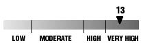
UV index
The ultraviolet index rates your risk to sun exposure. The higher the number, the greater the risk. Listed is tomorrow's forecast: 15 is the greatest risk.
The tides
Three-day forecast for Honolulu:
DAY	HIGH			LOW
Tues.	7:12a.m.	1.7 ft.	12:22a.m.	0.4 ft.
	6:48p.m.	1.2 ft.	1:37p.m.	0.7 ft.

Wed.	8:09a.m.	1.7 ft.	12:55a.m.	0.4 ft.
	7:35p.m.	1.0 ft.	3:04p.m.	0.8 ft.

Thurs.	9:17a.m.	1.7 ft.	1:34a.m.	0.5 ft.
	8:50p.m.	0.9 ft.	4:54p.m.	0.8 ft.
Elsewhere throughout the state tomorrow:
PLACE		HIGH	LOW	HIGH	LOW
Haleiwa		6:10	11:32	5:46	10:50
Hilo		6:08	-----	5:44	12:38
Kailua-Kona	6:46	12:00	6:22	1:15
Kaneohe		5:26	-----	5:02	12:19
Kawaihae	7:08	12:19	6:44	1:34
Kealakekua	6:56	12:10	6:32	1:25
Nawiliwili	6:45	-----	6:21	1:12
Waianae		9:32	2:40	9:08	3:55
Waimanalo	5:57	-----	5:33	12:28
THE PACIFIC
Volcanoes Observatory