

Three-day forecast
Tomorrow: Sunshine mixed with clouds and windy at times. Wind NE at 12-25 mph. 70/86
Surf forecast
Marine forecast
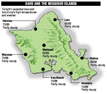
Neighbor island forecasts
Temperatures listed are tonight's expected lows and tomorrow's highs:
Kilauea
Lava continues flowing underground through a lava tube to the sea creating a large steam cloud where it enters the ocean.
Temperature
At Honolulu Airport:
High yesterday -- 87
Low yesterday -- 74
Record high -- 93 (1997)
Record low -- 68 (1987)
Normal high -- 89
Normal low -- 74
Rain
Humidity -- 56%
Yesterday -- trace
Month-to-date -- 0.06"
Normal month-to-date -- 0.42"
Year-to-date -- 6.88"
Normal year-to-date -- 12.14"
Sun and Moon
Sunset tonight -- 6:50 p.m.
Sunrise tomorrow -- 6:15 a.m.
Moonset tonight -- 9:48 a.m.
Moonrise tomorrow -- 10:39 p.m.Phases of the moon:
Last	Sep 2	New	Sep 9
First	Sep 17	Full	Sep 25
UV index
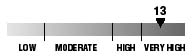
The ultraviolet index rates your risk to sun exposure. The higher the number, the greater the risk. Listed is tomorrow's forecast: "15 is the greatest risk".
The tides
Three-day forecast for Honolulu:
DAY	HIGH			LOW
Tues.	7:46a.m.	1.7 ft.	1:01a.m.	0.2 ft.
	7:17p.m.	1.4 ft.	1:53p.m.	0.7 ft.

Wed.	8:57a.m.	1.8 ft.	1:44a.m.	0.2 ft.
	8:15p.m.	1.1 ft.	3:35p.m.	0.8 ft.

Thurs.	10:14a.m.	1.9 ft.	2:36a.m.	0.3 ft.
	9:39p.m.	1.0 ft.	5:28p.m.	0.7 ft.
Elsewhere throughout the state tomorrow:
PLACE		HIGH	LOW	HIGH	LOW
Haleiwa		6:44	11:48	6:15	11:39
Hilo		6:42	12:02	6:13	12:54
Kailua-Kona	7:20	12:39	6:51	1:31
Kaneohe		6:00	-----	5:31	12:35
Kawaihae	7:42	12:58	7:13	1:50
Kealakekua	7:30	12:49	7:01	1:41
Nawiliwili	7:19	12:36	6:50	1:28
Waianae		10:06	3:19	9:37	4:11
Waimanalo	6:31	-----	6:02	12:44
THE PACIFIC
Volcanoes Observatory