

Three-day forecast
Tomorrow: Partly to mostly sunny; mainly windward showers. Wind E at 12-25 mph. 73/88
Surf forecast
Marine forecast
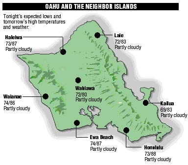
Neighbor Island forecasts
Temperatures listed are tonight's expected lows and tomorrow's highs:
Kilauea
Eruption of Kilauea continues. Lava is flowing down the mountain on the surface to the sea.
Temperature
At Honolulu Airport:High yesterday -- 85
Low yesterday -- 72
Record high -- 91 (1988)
Record low -- 69 (1981)
Normal high -- 88
Normal low -- 74
Rain
Humidity -- 67%
Yesterday -- 0.01"
Month-to-date -- 0.41"
Normal month-to-date -- 0.33"
Year-to-date -- 6.66"
Normal year-to-date -- 11.46"
Sun and Moon
Sunset tonight -- 7:16 p.m.
Sunrise tomorrow -- 6:00 a.m.
Moonset tonight -- none
Moonrise tomorrow -- 1:07 p.m.Phases of the moon:
First -- July 19
Full -- July 28
Last -- Aug 4
New -- Aug 11
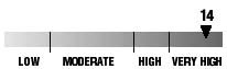
UV index
The ultraviolet index rates your risk to sun exposure. The higher the number, the greater the risk. Listed is tomorrow's forecast: "15 is the greatest risk".
The tides
Three-day forecast for Honolulu:
DAY	HIGH			LOW
Tues.	11:32a.m.	1.4 ft.	4:11a.m.	0.2 ft.
	9:59p.m.	1.1 ft.	5:30p.m.	0.8 ft.

Wed.	-----			4:51a.m.	0.2 ft.
	12:25p.m.	1.6 ft.	7:06p.m.	0.8 ft.

Thurs.	-----			5:31a.m.	0.2 ft.
	1:09p.m.	1.8 ft.	8:11p.m.	0.7 ft.
Elsewhere throughout the state tomorrow:
PLACE		HIGH	LOW	HIGH	LOW
Haleiwa		10:30	2:06	8:57	3:25
Hilo		10:28	3:12	8:55	4:31
Kailua-Kona	11:06	3:49	9:33	5:08
Kaneohe		9:46	2:53	8:13	4:12
Kawaihae	11:28	4:08	9:55	5:27
Kealakekua	11:16	3:59	9:43	5:18
Nawiliwili	11:05	3:46	9:32	5:05
Waianae		-----	6:29	1:52	7:48
Waimanalo	10:17	3:02	8:44	4:21
THE PACIFIC
Volcanoes Observatory