
By Craig T. Kojima, Star-Bulletin
Pao-Shin Chu, UH associate professor of meteorology,
says that the North Pacific has seen more
tropical cyclones this decade.
Hurricane charting
over decades shows
activity picking up
A normal season is predicted
By Helen Altonn
this year, but 'it only takes one'
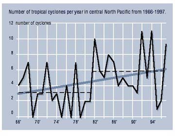
Star-BulletinALTHOUGH a normal hurricane season is predicted this year, a University of Hawaii study shows a long-scale upward trend in tropical cyclone activity.
Meteorologist Pao-shin Chu investigated tropical cyclones -- which include depressions, storms and hurricanes -- from 1966 to 1997 to see if there were variations from one decade to another.
He focused on storms that entered from the east or formed in the central North Pacific, where the Hawaiian Islands are located. His findings have been accepted tentatively for this month's issue of the American Meteorological Society journal.
Jim Weyman, Central Pacific Hurricane Center director, said a normal hurricane season usually means four to five tropical cyclones occurring in the central Pacific.
"Normally, we have one hurricane, two storms and two depressions," he said.But whether it's an exceptionally active or inactive season, Weyman emphasized, "it only takes one. Look at 1992 in Florida. It was a very inactive season. Then Andrew caused devastation. It only takes one if it moves in the right direction."
Chu said he found major differences in the two decades he examined, with much more activity in the last 10 years.
No tropical cyclones occurred in 1969, 1975, 1977 and 1979, Chu pointed out. However, he said, "Since 1981, no one year hasn't had any activity."
The most active years were 1992 and 1994 -- each with 11 tropical cyclones, Chu said. Three strong hurricanes occurred in 1991.
Again in 1994, there were 11 tropical cyclones, including three hurricanes in Category 5, the maximum strength.
That was the first time any hurricane that strong had been reported in the central North Pacific, Chu said.
All three -- John, Gilma and Emilia -- traveled south of Hawaii. If any had turned toward the islands, it would have been devastating, Chu pointed out. "It was really scary, particularly after (Hurricane) Iniki (in 1992), when memory was still fresh."
At least six hurricanes formed in the western half of the North Pacific from 1982 to 1987, Chu said. Only two formed in the same region from 1966 to 1981 and they were very weak, he said.
He believes climate variations from decade to decade are more related to the El Nino phenomenon than global warming, but the relationships aren't well understood yet, he said.
El Ninos are associated with warmer water south of Hawaii, while La Ninas are related to cooler water and weather in the equatorial central and eastern Pacific.
"We are seeing stronger and more frequent El Ninos," Chu said, speculating that may be one reason for more tropical cyclones in the North Pacific.
He said the sea surface temperature since the late 1970s has shifted from a cold to warm phase, becoming warmer south of Hawaii by 1 degree centigrade.
"If you superimpose the two features -- the sea surface temperature and warm background -- El Nino becomes larger," he said, noting very strong El Ninos in 1982-83 and 1997-98.
Changes from decade to decade might be useful in developing models to predict tropical cyclone activity several months in advance, Chu said.
But more studies are needed, he said, noting that most meteorologists have been looking at climate variations from year to year. "Already things are very complicated, and the decadal time scale is much longer."

