

Three-day forecast
Tomorrow: Mostly cloudy with a shower or two; breezy. Wind E at 12-24 mph. 71/84
Surf forecast
Marine forecast
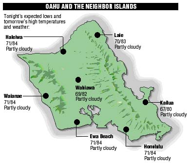
Neighbor Island forecasts
Temperatures listed are tonight's expected lows and tomorrow's highs:
Kilauea
Eruption of Kilauea continues. Lava is flowing underground in a 6 mile lava tube to the sea.
Temperature
At Honolulu Airport:High yesterday -- 86
Low yesterday -- 74
Record high -- 91 (1987)
Record low -- 66 (1959)
Normal high -- 87
Normal low -- 72
Rain
Humidity -- 64%
Yesterday -- trace
Month-to-date -- 0.03"
Normal month-to-date -- 0.34"
Year-to-date -- 6.17"
Normal year-to-date -- 10.97"
Sun and Moon
Sunset tonight -- 7:16 p.m.
Sunrise tomorrow -- 5:50 a.m.
Moonset tonight -- none
Moonrise tomorrow -- 12:44 p.m.Phases of the moon:
First -- June 20
Full -- June 28
Last -- July 6
New -- July 12
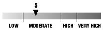
UV index
The ultraviolet index rates your risk to sun exposure. The higher the number, the greater the risk. Listed is tomorrow's forecast: "15 is the greatest risk".
The tides
Three-day forecast for Honolulu:
DAY	HIGH			LOW
Sun.	11:25a.m.	1.0 ft.	4:37a.m.	0.0 ft.
	10:02p.m.	1.3 ft.	4:09p.m.	0.7 ft.

Mon.	-----			5:16a.m.	0.0 ft.
	12:20p.m.	1.2 ft.	5:48p.m.	0.7 ft.
Tues.	-----			5:50a.m.	0.0 ft.
	1:04p.m.	1.4 ft.	7:11p.m.	0.6 ft.
Elsewhere throughout the state tomorrow:
PLACE		HIGH	LOW	HIGH	LOW
Haleiwa		10:23	2:32	9:00	2:04
Hilo		10:21	3:38	8:58	3:10
Kailua-Kona	10:59	4:15	9:36	3:47
Kaneohe		9:39	3:19	8:16	2:51
Kawaihae	11:21	4:34	9:58	4:06
Kealakekua	11:09	4:25	9:46	3:57
Nawiliwili	10:58	4:12	9:35	3:44
Waianae		-----	6:55	1:45	6:27
Waimanalo	10:10	3:28	8:47	3:00
THE PACIFIC
Volcanoes Observatory