

THREE-DAY FORECAST
Tomorrow: Clouds and sun; windy; a few showers. Wind E at 12-24 mph. 73/85
SURF FORECAST
MARINE FORECAST
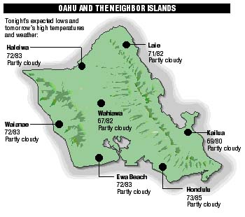
NEIGHBOR ISLAND FORECASTS
TEMPERATURES LISTED ARE TONIGHT'S EXPECTED LOWS AND TOMORROW'S HIGHS:
KILAUEA
A pause in Kilaeau's east rift eruption which began Monday continued yesterday.
TEMPERATURE
AT HONOLULU AIRPORT:High yesterday -- 86
Low yesterday -- 72
Record high -- 91 (1967)
Record low -- 68 (1959)
Normal high -- 87
Normal low -- 72
RAIN
Humidity -- 74%Yesterday -- 0.01"
Month-to-date -- 0.03"
Normal month-to-date -- 0.32"
Year-to-date -- 6.17"
Normal year-to-date -- 10.95"
SUN AND MOON
Sunset tonight -- 7:15 p.m.Sunrise tomorrow -- 5:50 a.m.
Moonset tonight -- 11:12 p.m.
Moonrise tomorrow -- 10:58 a.m.
PHASES OF THE MOON:
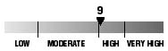
First	June 20	Full	June 28
Last	July 6	New	July 12
UV INDEX
The ultraviolet index rates your risk to sun exposure. The higher the number, the greater the risk. Listed is tomorrow's forecast: "15 is the greatest risk".
THE TIDES
THREE-DAY FORECAST FOR HONOLULU:
DAY	HIGH			LOW
Fri.	8:49a.m.	0.7 ft.	3:07a.m.	0.0 ft.
	8:21p.m.	1.8 ft.	1:10p.m.	0.4 ft.

Sat.	10:13a.m.	0.8 ft.	3:54a.m.	0.0 ft.
	9:11p.m.	1.6 ft.	2:31p.m.	0.6 ft.

Sun.	11:25a.m.	1.0 ft.	4:37a.m.	0.0 ft.
	10:02p.m.	1.3 ft.	4:09p.m.	0.7 ft.
ELSEWHERE THROUGHOUT THE STATE TOMORROW:
PLACE		HIGH	LOW	HIGH	LOW
Haleiwa		7:47	1:02	7:19	-----
Hilo		7:45	2:08	7:17	12:11
Kailua-Kona	8:23	2:45	7:55	12:48
Kaneohe		7:03	1:49	6:35	-----
Kawaihae	8:45	3:04	8:17	1:07
Kealakekua	8:33	2:55	8:05	12:58
Nawiliwili	8:22	2:42	7:54	12:45
Waianae		11:09	5:25	10:41	3:28
Waimanalo	7:34	1:58	7:06	12:01
THE PACIFIC
Volcanoes Observatory