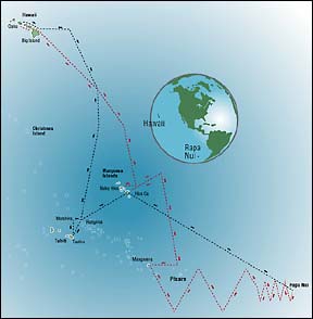
1. Hilo to Marquesas Islands
 When: June-July
Distance: 1,900 miles
Strategy: Hokule'a sails east of the Marquesas before turning west to search for the islands, using land-based seabirds to guide it to Hiva Oa.
Weather: Westerly currents are weak and variable at about .5 knots. Light winds, dense cloud cover and confused swells make navigation difficult midway during this leg. Easterly winds increase to 13-14 knots as Hokule'a nears Marquesas.
Navigator: Bruce Blakenfeld
2. Marquesas Islands to Mangareva
When: July-August
Distance: 900 miles
Strategy: To avoid the dangerous atolls of Tuamotu Archipelago, Hokule'a tacks north, then south, to get east of Pitcairn before heading west following land-based seabirds.
Weather: Westerly current at about .5 knots; winds easterly 13-14 knots.
Navigator: Chad Baybayan
3. Mangareva to Rapa Nui
When: September-October
Distance: 1,450 miles
Strategy: Hokule'a tacks easterly and begins a zigzagging search pattern about 300 miles from the island, which can be spotted from the mast 40 miles away. Hokule'a cannot rely on land-based seabirds because they are extinct, destroyed by hawks introduced to control rats.
Weather: Easterly currents weak; easterly winds average 12 knots, and 7-27 knots 82% of the time on this leg.
Navigator: Nainoa Thompson
4. Rapa Nui to Tahiti
When: October-November
Distance: 2,400 miles
Strategy: Hokule'a targets the Marquesas Islands and heads westerly to Rangiroa, Matahiva and Tahiti.
Weather: Current weak; winds easterly 13-14 knots.
Navigator: Bruce Blakenfeld
5. Tahiti to Hilo
When: December-January, 2000
Distance: 2,400 miles
Strategy: Hokule'a sails north to about 300 miles east of the Big Island before heading west. Mauna Kea points the way.
Weather: Again, light, shifting winds, dense cloud cover and confused swells make navigation difficult midway during this leg.
Navigator: Nainoa Thompson
Sources: NOVA Online; World Book Encyclopedia; Polynesian Voyaging Society