

THREE-DAY FORECAST
Tomorrow: Sunny to partly cloudy; a shower in spots. Wind SE at 8-16 mph. 74/84
SURF FORECAST
MARINE FORECAST
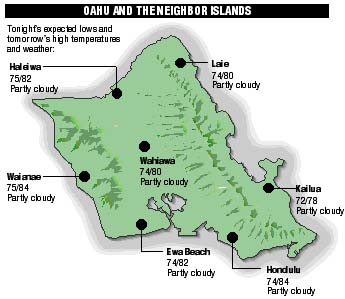
NEIGHBOR ISLAND FORECASTS
Temperatures listed are tonight's expected lows and tomorrow's highs:
KILAUEA
Eruption of Kilauea continues. Lava is flowing underground in a 6 mile lava tube to the sea.
TEMPERATURE
At Honolulu Airport:
High yesterday -- 82
Low yesterday -- 69
Record high -- 91 (1996)
Record low -- 64 (1983)
Normal high -- 85
Normal low -- 71
RAIN
Humidity -- 69%
Yesterday -- 0.00"
Month-to-date -- 2.10"
Normal month-to-date -- 0.83"
Year-to-date -- 6.10"
Normal year-to-date -- 10.33"
SUN AND MOON
Sunset tonight -- 7:05 p.m.Sunrise tomorrow -- 5:51 a.m.
Moonset tonight -- 1:16 a.m.
Moonrise tomorrow -- 1:59 p.m.
Phases of the moon:
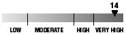
Full	May 29	Last	June 6
New	June 13	First	June 20
UV INDEX
The ultraviolet index rates your risk to sun exposure. The higher the number, the greater the risk. Listed is tomorrow's forecast: "15 is the greatest risk".
THE TIDES
Three-day forecast for Honolulu:
DAY	HIGH			LOW
Sun.	-----			6:13a.m.	-0.1 ft.
	12:53p.m.	1.1 ft.	6:05p.m.	0.5 ft.

Mon.	-----			6:45a.m.	-0.2 ft.
	1:32p.m.	1.3 ft.	7:15p.m.	0.5 ft.

Tues.	12:39a.m.	1.1 ft.	7:12a.m.	-0.2 ft.
	2:06p.m.	1.5 ft.	8:13p.m.	0.4 ft.
Elsewhere throughout the state tomorrow:
PLACE		HIGH	LOW	HIGH	LOW
Haleiwa		11:51	4:08	10:50	4:00
Hilo		11:49	5:14	10:48	5:06
Kailua-Kona	-----	5:51	12:27	5:43
Kaneohe		11:07	4:55	10:06	4:47
Kawaihae	-----	6:10	12:49	6:02
Kealakekua	-----	6:01	12:37	5:53
Nawiliwili	-----	5:48	12:26	5:40
Waianae		1:20	8:31	3:13	8:23
Waimanalo	11:38	5:04	10:37	4:56
THE PACIFIC
Volcanoes Observatory