Prehistory to 1780: Ancient Hawaii to
Western Discovery
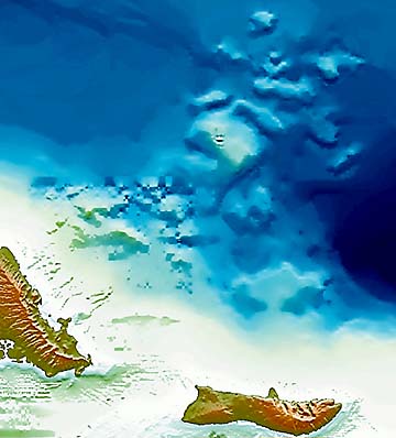
In this computer-made map of Oahu, the Nuuanu
landslide is seen. Debris, amounting to nearly a third
of the island, fell off the Windward side. The data
was compiled by J.R. Smith and Terri Duennebier
from underwater mapping done by the University
of Hawaii. The Pali and other sheer cliffs are not a
wall of the Koolau crater, but were produced by erosion.
Nuuanu landslide
tore Oahu apartIt's the biggest of at least 17 debris
By John Sinton
slides off the island's shore
Special to the Star-BulletinAges after they were created by volcanoes, the Hawaiian Islands continue to be reshaped today from erosion by streams and ocean.
For most of this century, geologists thought erosion occurred over long periods, the result of waters cutting valleys and shaving shorelines.
But in the last few decades, we have learned that much more dramatic events have sheared away large chunks of the islands in relatively short times.
Sonar mapping around the islands reveal at least 17 offshore features caused by such events. Although relatively little detail is known, variations in internal structure suggest these features resulted from different types of landslides.
For example, deposits lying southeast of the Big Island and west of the Waianae Volcano appear to have been formed by relatively slow, intermittent slip along fault planes; these are called slump deposits.
Others contain evidence of more catastrophic events: jumbled blocks in chaotic array deposited by relatively fast-moving debris avalanches.
The largest of these is the great Nuuanu Debris Avalanche, which swept material more than 140 miles north of Oahu and Molokai. For the last 85 miles of its journey, the avalanche traveled uphill by about 1000 feet, leaving jumbled blocks -- once part of Oahu -- scattered over more than 9000 square miles of seafloor.
Tuscaloosa Seamount, thelargest of these blocks, is a rock mass about 19 miles by 11 miles which rises more than a mile up from the surrounding seafloor. The event responsible for this debris deposit, including the seamount, removed a huge chunk of the old Koolau shield volcano in southeast Oahu.
Though its precise age is unknown, the Nuuanu Debris Avalanche did not occur until after the Koolau volcano became extinct about 1.5 million years ago.
But it also is clear that this event had split off much of Oahu before the Honolulu Volcanics -- which created Rabbit Island, the young lava flow at Makapuu Beach Park, Mokapu Peninsula on the windward side, in addition to the famous landmarks of Diamond Head, Punchbowl, and Hanauma Bay.
Those features began forming about a half-million years ago -- so the age of the Nuuanu "event" is 1 million years, plus or minus half-million.
Ever since the Nuuanu Debris Avalanche was recognized several decades ago, geologists have wondered about its relationship to the great Nuuanu Pali. Some speculate that the Pali is actually the fault scarp from which the landslide originated, but much evidence indicates otherwise.
For example, features like Olomana and Mokulua Islands are relatively undisturbed, indicating that the great slip plane lies further north. And recent mapping by University of Hawaii geologists has identified a large submarine cliff that probably represents Oahu's main structural break.
Recent work has renewed interest in submarine landslides -- and raised more questions about the Nuuanu avalanche, which must have been the most catastrophic event to affect the Hawaiian Islands.
When a third of Oahu broke off and disappeared below sea level, did it happen all at once? Was there a huge noise when the rock heaved and roared into the ocean? Such a landslide almost surely generated a huge tsunami, though such an effect has yet to be evidenced.
Nevertheless, landslides can be the most destructive natural hazard in the Hawaiian Islands. The good news is that massive landslides are relatively infrequent: the 17 deposits identified offshore around the inhabited Hawaiian islands formed over 6 million years, or one every 350,000 years on average.
The Hilina slump along the Big Island's southeast coast continues to form today, with the large Kamoamoa earthquake of 1975 being the last significant movement linked to its formation.
Massive landsliding is a recurring phenomenon in the history of Hawaii's islands. And it has forever changed the way geologists view island evolution.
3.5 inches: Distance Hawaiian tectonic plate moves west-northwest each year. The numbers
500,000 years: Average period a Hawaiian volcano is at its peak.
3,200 feet: Depth Loihi must climb before breaking the ocean's surface, probably in 200,000 years.
100 years: Time during which geologists expect Haleakala and Hualalai to erupt.
John Sinton has been on the University of Hawaii
faculty since 1977. He is a professor and chairman
of the Geology and Geophysics Department. The
National Science Foundation has funded his research
of submarine and Hawaiian volcanoes. He holds degrees
in geology from theUniversity of California Santa Barbara,
University of Oregon and Otago University (New Zealand).Millennium Series Archive