

THREE-DAY FORECAST
Tomorrow: Sun and clouds; showers in spots. Wind SE at 8-16 mph. 72/80
SURF FORECAST
MARINE FORECAST
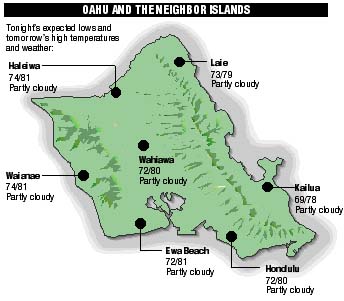
NEIGHBOR ISLAND FORECASTS
Temperatures listed are tonight's expected lows and tomorrow's highs:
KILAUEA
Eruption of Kilauea continues. Lava is flowing underground in a 6 mile lava tube to the sea.
TEMPERATURE
At Honolulu International Airport:High yesterday -- 82
Low yesterday -- 69
Record high -- 87 (1994)
Record low -- 62 (1995)
Normal high -- 84
Normal low -- 69
RAIN
Humidity -- 61%
Yesterday -- trace
Month-to-date -- 0.67"
Normal month-to-date -- 1.54"
Year-to-date -- 3.99"
Normal year-to-date -- 9.50"
SUN AND MOON
Sunset tonight -- 6:57 p.m.
Sunrise tomorrow -- 6:00 a.m.
Moonset tonight -- 7:00 a.m.
Moonrise tomorrow -- 9:01 p.m.Phases of the moon:
Last	May 8	New	May 15
First	May 21	Full	May 29
UV INDEX
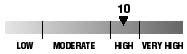
The ultraviolet index rates your risk to sun exposure. The higher the number, the greater the risk. Listed is tomorrow's forecast: "15 is the greatest risk".
THE TIDES
Three-day forecast for Honolulu:
DAY	HIGH			LOW
Sun.	4:48a.m.	0.7 ft.	10:25a.m.	-0.1 ft.
	5:38p.m.	1.8 ft.	 --

Mon.	5:25a.m.	0.6 ft.	12:43a.m.	0.2 ft.
	6:18p.m.	1.8 ft.	 --

Tues.	6:09a.m.	0.5 ft.	1:40a.m.	0.2 ft.
	7:02p.m.	1.7 ft.	 --
Elsewhere throughout the state tomorrow:
PLACE		HIGH	LOW	HIGH	LOW
Haleiwa		3:46	8:20	4:36	10:38
Hilo		3:44	9:26	4:34	11:44
Kailua-Kona	4:22	10:03	5:12	 --
Kaneohe		3:02	9:07	3:52	11:25
Kawaihae	4:44	10:22	5:34	 --
Kealakekua	4:32	10:13	5:22	 --
Nawiliwili	4:21	10:00	5:11	 --
Waianae		7:08	2:11	7:58	12:43
Waimanalo	3:33	9:16	4:23	11:34
THE PACIFIC
Volcanoes Observatory