

Three-day forecast
Tomorrow: Sunshine and patchy clouds; showers inland. Wind SE at 10-20 mph. 68/82
Surf forecast
Marine forecast
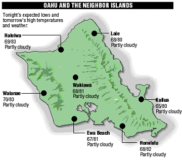
Neighbor Island Forecasts
Temperatures listed are tonight's expected lows and tomorrow's highs:
Kilauea
Eruption of Kilauea continues. Lava is flowing underground in a 6 mile lava tube to the sea.
Temperature
High yesterday -- 84
Low yesterday -- 71
Record high -- 89 (1978)
Record low -- 62 (1995)
Normal high -- 84
Normal low -- 69
Humidity -- 65%
Rain
Yesterday -- 0.00"
Month-to-date -- 0.67"
Normal month-to-date -- 1.46"
Year-to-date -- 3.99"
Normal year-to-date -- 9.42"
Sun and Moon
Sunset tonight -- 6:56 p.m.
Sunrise tomorrow -- 6:02 a.m.
Moonset tonight -- 5:44 a.m.
Moonrise tomorrow -- 7:21 p.m.Phases of the moon:
Full -- Apr 30
Last -- May 8
New -- May 15
First -- May 21
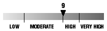
UV index
The ultraviolet index rates your risk to sun exposure. The higher the number, the greater the risk. Listed is tomorrow's forecast: "15 is the greatest risk".
The tides
Three-day forecast for Honolulu:
DAY	HIGH			LOW
Fri.	3:42a.m.	1.0 ft.	9:35a.m.	-0.2 ft.
	4:29p.m.	1.7 ft.	11:07p.m.	0.1 ft.

Sat.	4:14a.m.	0.9 ft.	9:59a.m.	-0.1 ft.
	5:02p.m.	1.8 ft.	11:53p.m.	0.2 ft.

Sun.	4:48a.m.	0.7 ft.	10:25a.m.	-0.1 ft.
	5:38p.m.	1.8 ft.	-----
Elsewhere throughout the state tomorrow:
PLACE		HIGH	LOW	HIGH	LOW
Haleiwa		2:40	7:30	3:27	9:02
Hilo		2:38	8:36	3:25	10:08
Kailua-Kona	3:16	9:13	4:03	10:45
Kaneohe		1:56	8:17	2:43	9:49
Kawaihae	3:38	9:32	4:25	11:04
Kealakekua	3:26	9:23	4:13	10:55
Nawiliwili	3:15	9:10	4:02	10:42
Waianae		6:02	12:42	6:49	-----
Waimanalo	2:27	8:26	3:14	9:58
THE PACIFIC
Volcanoes Observatory