

Three-day forecast
Tomorrow: Partly sunny with mainly windward showers. Wind E at 10-20 mph. 64/80
Surf forecast
Marine forecast
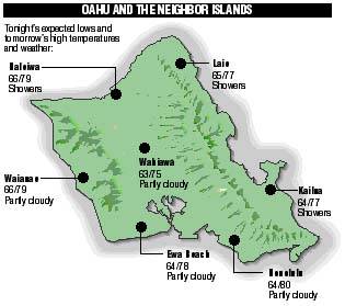
Neighbor island FORECASTS
Temperatures listed are tonight's expected lows and tomorrow's highs:
Kona - Partly cloudy tonight. Low 70. Sunny to partly cloudy tomorrow. High 79.
Kilauea
Eruption of Kilauea continues. Lava is flowing underground in a 6 mile lava tube to the sea.
Temperature
At Honolulu Airport:High yesterday -- 80
Low yesterday -- 68
Record high -- 88 (1996)
Record low -- 63 (1992)
Normal high -- 83
Normal low -- 69
Rain
Humidity -- 68%Yesterday -- 0.09"
Month-to-date -- 0.46"
Normal month-to-date -- 0.63"
Year-to-date -- 3.78"
Normal year-to-date -- 8.59"
Sun and Moon
Sunset tonight -- 6:50 p.m.Sunrise tomorrow -- 6:15 a.m.
Moonset tonight -- 3:44 p.m.
Moonrise tomorrow -- 4:38 a.m.
Phases of the moon:
New	Apr 15	First	Apr 22
Full	Apr 30	Last	May 8
UV index
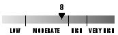
The ultraviolet index rates your risk to sun exposure. The higher the number, the greater the risk. Listed is tomorrow's forecast: "15 is the greatest risk".
The tides
Three-day forecast for Honolulu:
DAY	HIGH			LOW
Tues.	2:03a.m.	1.6 ft.	8:34a.m.	-0.2 ft.
	2:42p.m.	1.4 ft.	8:35p.m.	0.0 ft.

Wed.	2:43a.m.	1.6 ft.	9:04a.m.	-0.3 ft.
	3:23p.m.	1.6 ft.	9:29p.m.	-0.1 ft.

Thurs.	3:24a.m.	1.4 ft.	9:35a.m.	-0.3 ft.
	4:06p.m.	1.8 ft. 10:24p.m.	-0.1 ft.
Elsewhere throughout the state tomorrow:
PLACE	HIGH	LOW	HIGH	LOW
Haleiwa	1:01	6:29	1:40	6:30
Hilo	12:59	7:35	1:38	7:36
Kailua-Kona	1:37	8:12	2:16	8:13
Kaneohe	12:17	7:16	12:56	7:17
Kawaihae	1:59	8:31	2:38	8:32
Kealakekua	1:47	8:22	2:26	8:23
Nawiliwili	1:36	8:09	2:15	8:10
Waianae	4:23	10:52	5:02	10:53
Waimanalo	12:48	7:25	1:27	7:26
THE PACIFIC
Volcanoes Observatory