

THREE-DAY FORECAST
Tomorrow: Limited sunshine with a few showers. Wind E at 20-30 mph. 62/74
SURF FORECAST
MARINE FORECAST
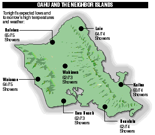
NEIGHBOR ISLAND FORECASTS
Temperatures listed are tonight's expected lows and tomorrow's highs:
Kona - Partly cloudy tonight. Low 70. Mostly sunny tomorrow. High 80.
KILAUEA
No red lava is visible at aslowly moving flow near the coast, but glow from two "skylights" can be seen at night.
TEMPERATURE
At Honolulu Airport:High yesterday - 82
Low yesterday - 71
Record high - 88 (1995)
Record low - 60 (1975)
Normal high - 83
Normal low - 69
RAIN
Humidity - 64%
Yesterday - 0.03"
Month-to-date - 0.25"
Normal month-to-date - 0.53"
Year-to-date - 3.57"
Normal year-to-date - 8.49"
SUN AND MOON
Sunset tonight - 6:49 p.m.
Sunrise tomorrow - 6:16 a.m.
Moonset tonight - 1:49 p.m.
Moonrise tomorrow - 3:08 a.m.Phases of the moon:
New	Apr 15	First	Apr 22
Full	Apr 30	Last	May 8
UV INDEX
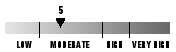
The ultraviolet index rates your risk to sun exposure. The higher the number, the greater the risk. Listed is tomorrow's forecast: "15 is the greatest risk".
THE TIDES
Three-day forecast for Honolulu:
DAY	HIGH			LOW
Sun.	12:37a.m.	1.6 ft.	7:37a.m.	0.0 ft.
	1:23p.m.	0.9 ft.	6:45p.m.	0.1 ft.

Mon.	1:21a.m.	1.7 ft.	8:06a.m.	-0.1 ft.
	2:02p.m.	1.1 ft.	7:42p.m.	0.1 ft.

Tues.	2:03a.m.	1.6 ft.	8:34a.m.	-0.2 ft.
	2:42p.m.	1.4 ft.	8:35p.m.	0.0 ft.
Elsewhere throughout the state tomorrow:
PLACE	HIGH	LOW	HIGH	LOW
Haleiwa	-----	5:32	12:21	4:40
Hilo	-----	6:38	12:19	5:46
Kailua-Kona	12:11	7:15	12:57	6:23
Kaneohe	11:37	6:19	11:35	5:27
Kawaihae	12:33	7:34	1:19	6:42
Kealakekua	12:21	7:25	1:07	6:33
Nawiliwili	12:10	7:12	12:56	6:20
Waianae	2:57	9:55	3:43	9:03
Waimanalo	-----	6:28	12:08	5:36
THE PACIFIC
Volcanoes Observatory