UH scientists bathe in volcanic mudflow data
They saw a breakout of a pile of debris from a lake in New Zealand
University of Hawaii at Manoa volcanologists were "in the right place at the right time" when a volcanic mudflow broke through the banks of a lake on New Zealand's Mount Ruapehu, said Sarah Fagents.
The UH-Manoa volcanologist and colleague Bruce Houghton, with the School of Ocean, Earth Science and Technology, were on the mountain doing fieldwork to prepare for a mudflow "predicted to happen at some point," Fagents said in an interview yesterday.
"We thought it would be next year," she said. "We went to look at the volcano and channel way ahead of time so we would have a sense of where the lahar (mudflow) would be flowing and the kind of conditions it would encounter."
But on March 18, the Crater Lake breakout occurred, giving the UH scientists a rare opportunity to study the immediate aftermath.
A lahar is a type of mudflow of water, rocks, sediments and other material flowing down from a volcano with great speed and increasing size, usually along a river valley.
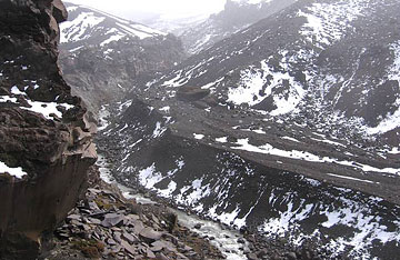 COURTESY REBECCA CAREY The lahar channel before the collapse of the Crater Lake walls. CLICK FOR LARGE |
|
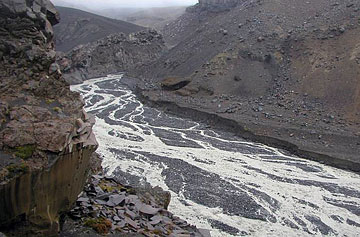 COURTESY SARAH FAGENTS The lahar channel after the collapse of the Crater Lake walls. CLICK FOR LARGE |
|
The Crater Lake breakout released about 1.3 million cubic meters of water, which increased as eroded sediments were swept into the flow, the volcanologists reported.
Mount Ruapehu is a relatively unpopulated area but similar events can be life-threatening in areas such as Mount Rainier in Washington state and Galunggung in Indonesia, where large populations live on or around volcanoes, Fagents said.
More than 1,300 people were killed last year in the Philippines when a typhoon dislodged tens of thousands of tons of volcanic ash and debris from Mayon volcano.
No one was hurt in the Ruapehu mudflow, largely because authorities had installed a good warning system, with automatic road closures, Fagents said.
Volcanologists at New Zealand's Geological Nuclear Science Institute had spent some time studying pathways the lahar would take, she said. Fagents and Houghton worked with New Zealand volcanologist Vernon Manville, who coordinated the scientific response to the lahar, she said.
New Zealand scientists had installed an unprecedented amount of instruments in anticipation of the Crater Lake breakout, she said. "Because of this, the 2007 event will be by far the best studied lahar in the world."
Initially, it was expected to occur this year, then the forecast shifted to 2008 because of diminishing snow melt and a little seepage in the lake bank, which kept the water level from rising, Fagents said.
But a few days before the breakout, she said, there was "some really atrocious weather, rain and sleet. I know because I was out there at the time."
The extra water in the lake put pressure against the lake's wall and it collapsed, she said. A 16-foot-thick pile of material from a 1995-96 eruption was holding the lake back and eroding at the same time, she said.
The day of the mudflow, a group of UH geology students arrived for a class field trip and instead got an unusual chance to study results of a volcanic mudflow. Fagents was one of the class leaders and principal investigator for the mudflow study under a National Science Foundation grant.
The students interpreted flow conditions from observations at Tangiwai in a group project.
About 25 miles from the source at the Tangiwai Bridge, site of a 1953 lahar disaster, they saw a large devastated area covered with mud and boulders, Fagents said.
She said the mudflow traveled all the way to the ocean, leaving a "spectacular" deposit.
The flow damaged road and rail bridges, creating access problems to some farms, and it overran a memorial for a 1953 tragedy, when a railroad bridge was destroyed and a train plummeted into a gorge, killing 151 people, she said.
Fagents, Houghton and graduate students Chris Hamilton and Licia Costantini returned to New Zealand a month later for a more detailed study of the deposit.
"Having an understanding of how these things are initiated, how they're triggered, how they flow and move away from the source is very important," Fagents said.
Understanding the physics underlying the flow process can help predict how fast they flow and how big an area they will inundate downstream, she said.
The Ruapehu data will help her construct a more realistic computer model to simulate a volcanic mudflow and predict hazards, she said.

