More rain on way for Windward residents
There will be at least one more night of heavy showers, forecasters say
Windward Oahu residents should keep umbrellas and rain slickers handy.
The rain that drenched the area over the weekend will hang around, and there will be one more night of heavy showers, the National Weather Service said yesterday.
An unstable air mass responsible for the showers will continue to linger over the islands until tomorrow, said Henry Lau, Weather Service forecaster.
A flash-flood watch for Kauai, Oahu and Molokai was in effect until 10 p.m. yesterday.
ASSOCIATED PRESS
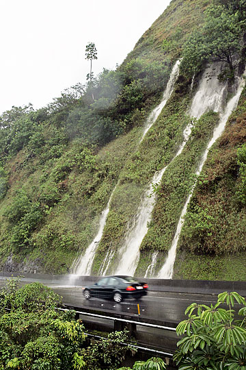
A waterfall poured down the mountains onto Pali Highway on Sunday. Heavy rains on the mountain range caused a high number of waterfalls, leading tourists and residents to stop along the Pali to take pictures.
|
|
"Every island has been getting some showers. Oahu got more because of the orientation of the Koolau Mountains in relation to the wind flow," Lau said.
Another factor is the added moisture in the air due to light winds and daytime heating, he said.
Kahaluu and Ahuimanu have been getting the heaviest rainfall on the island. In the 24 hours that ended at 2 p.m. yesterday, the rain gauge at the Waihee pump station recorded 4.63 inches. At Ahuimanu Loop the rainfall was 4.88 inches.
Luluku in Kaneohe got 4.12 inches, and Bellows Air Force Station got 3.67 inches in the same period.
Lau said the unstable air can create pockets of heavy showers even over the Leeward side of the island.
Over the same 24-hour period, Lualualei received 1.29 inches of rain, and Waianae Valley got 0.78 inches.
The forecast calls for scattered showers in Windward and mountain areas with isolated showers in Leeward areas.

