
COURTESY OF HAWAIIAN VOLCANO OBSERVATORY
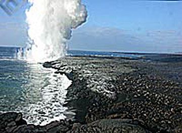
A "fire hose" of lava shot out of a newly formed, 100-foot-high cliff Tuesday. Today, the lava is continuing to flow down a "ramp" at the base of the cliff, seen here beginning to form.
|
|
40 acres of lava crash into the sea
Magma 'fire hose' replaces collapsed volcanic shelf
HILO » Geologists and park rangers were assessing the danger on the coast of Hawaii Volcanoes National Park yesterday following the collapse into the sea Monday of about 40 acres of lava land.
The collapse of 30 acres of coastal "bench" and 10 acres of old sea cliff behind the bench was the largest case of land falling into the sea since Kilauea began its nearly 23-year-long eruption in 1983, the Hawaiian Volcano Observatory said.
The disappearance of the land broke open an underground stream of lava that then flowed out of a new, 100-foot-high cliff face at the rate of about four truckloads of lava per second, said ranger Jim Gale.
The gush, called a "fire hose" by geologists, lasted uninterrupted for about 24 hours, with the bright stream of lava shooting 75 feet down into the ocean.
By yesterday morning the stream had created enough new rock at the base of the cliff to form a "ramp," but lava continued gushing down the ramp, said Jim Kauahikaua, scientist-in-charge of the Volcano Observatory.
Something similar had been expected since the end of June, when the park closed about the final mile of a trail that leads out to the bench. The end of the trail remained closed yesterday.
40 ACRES OF LAVA LAND:
NOW YOU SEE IT, NOW YOU DON'T
PHOTOS COURTESY OF HVO
The lava bench at East Laeapuki is shown on Nov. 21, above; by Tuesday, below, it had fallen and vanished.
|
|
Such lava benches build up periodically on old, unstable coastal sea floor and then disappear catastrophically. In 1993 a park visitor walking on a bench in violation of a park restriction disappeared in the ocean when the bench collapsed without warning.
Unlike some other collapses, Monday's event occurred in several phases over a period of 4 1/2 hours beginning at 11:10 a.m.
Geologists suspected what had happened because of seismic rumblings, but were not able to go to the coastal site until Tuesday.
The largest previous collapse was in 1996, when 34 acres fell into the sea. On Aug. 27, 11 acres fell into the sea.
Steam generated by water hitting hot rocks blasted rocks inland at the site, the observatory said.
Monday's collapse was followed about 35 hours later by a 4.5-magnitude earthquake about five miles from the collapse site. Geologists said the two events were not related.

