
Storm slowly
approaching isles
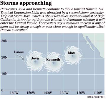
Hurricane Jova and Kenneth,
behind it, are likely to weaken
by the end of the week
Hurricane Jova slowed yesterday but continued on its northwesterly course toward the islands and is still expected to weaken when it reaches cooler waters about 400 miles east of the Big Island on Thursday, forecasters said.
"The forecast track still keeps it to the east of the islands on days four and five, but of course that could change," National Weather Service lead forecaster Tim Craig said yesterday.
He said it is still too early to know whether the islands will experience any of the hurricane's wind and rain, and residents should be prepared in the event the storm makes a sudden turn.
The Category 2 storm, with sustained winds of about 105 mph, is moving at about 8 mph.
It slowed early yesterday, from 11 mph.
By Thursday or Friday, Craig said, it is expected to weaken to a tropical storm, with winds of about 69 mph.
"The further north it gets, the colder the ocean waters are going to be," he said.
Jova, which was about 975 miles east-southeast of Hilo yesterday, precedes a second hurricane in the Pacific.
Hurricane Kenneth, a Category 4 storm, is 1,470 miles west-southwest of Baja California and 700 miles east of Jova.
It has sustained winds of about 132 mph and is moving west-northwest. The storm will still be in the eastern Pacific by the end of the week, by which time forecasters expect it to have weakened to a tropical storm.
Also yesterday, a tropical disturbance in the eastern Pacific intensified into a tropical storm and absorbed a second storm, Tropical Depression Lidia.
Weather service forecasters said Tropical Storm Max is about 640 miles south-southwest of Baja California. It is too far out from the islands to determine whether it will enter the Central Pacific.
Craig said it is not unusual for so many storms to form in the Pacific at once during hurricane season.
Jova, the Central Pacific's first hurricane of the year, is right on time, he said, adding that September is an active month for the Pacific.
Weather service forecasters predicted the Pacific would get two to three hurricanes by November, when this year's season ends.
www.prh.noaa.gov/hnl/cphc/
National Hurricane Center - Tropical Prediction Center
www.nhc.noaa.gov/
Tropical Storm Tracker
www.solar.ifa.hawaii.edu/Tropical/tropical.html
NWS Hawaii radar
weather.noaa.gov/radar/mosaic/DS.p19r0/ar.us.hi.shtml
E-mail to City Desk
[News] [Business] [Features] [Sports] [Editorial] [Do It Electric!]
[Classified Ads] [Search] [Subscribe] [Info] [Letter to Editor]
[Feedback]