
Hurricane expected
to weaken as it nears
Four storms that could
affect Hawaii are developing
The first hurricane to enter the Central Pacific this season is expected to maintain its intensity until Thursday, when it will reach cooler waters about 425 miles east of Hilo and slowly weaken, forecasters said.
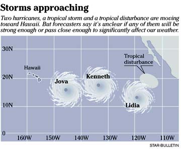
Hurricane Jova is one of three storms and a tropical disturbance that are approaching the islands, although it is unclear if any of them will bring significant weather.
The approach of Hurricane Jova, a category 2 storm with sustained winds of 105 miles per hour, has prompted Hawaii officials to call for residents to stock up on emergency supplies and map out a plan in the event of an evacuation.
"Even though we're not sure of the track," National Weather Service forecaster Jonathan Hoag said, "it is a good idea to be prepared for a situation that might warrant real action."
The storm is traveling west-northwest toward the islands at 11 mph. Over the next four days, it is forecast to weaken to a tropical storm, with winds of about 69 mph.
National Weather Service lead forecaster Bob Farrell said that Hawaii could get some weather from Hurricane Jova by late Friday or Saturday if it keeps to its current course.
Jova was about 1150 miles east-southeast of the Big Island yesterday.
Hurricane Kenneth is also progressing toward the islands. The category 3 hurricane, with winds of 120 mph and gusts of 140 mph, was about 1,815 miles east-southeast of Hilo yesterday and is moving at 11 mph.
It will move over cool waters today and is forecast to weaken to a tropical storm by Tuesday.
Also, a storm about 700 miles east of Kenneth was upgraded to a tropical storm yesterday. Forecasters are also watching Tropical Storm Lidia, but say it is not expected to reach hurricane strength. Another tropical disturbance formed behind Lidia, but it is unclear if it will strengthen.
With the storms moving toward the islands, first responders and the Hawaii National Guard are gearing up statewide and asking residents to do the same.
State Adjutant General Robert Lee said yesterday that the Hawaii Air National Guard has enough manpower locally to respond to a disaster, even with deployment of 3,000 Hawaii Army National Guard reservists to Iraq.
Hoag said residents should determine their home's vulnerability to storm surge, flooding and wind before a hurricane, while also locating their nearest shelter in the event of an evacuation. Other measures residents should take include:
» Checking their homes' insurance coverage. Flood damage is not usually covered by homeowners' insurance.
» Making a plan for what to do with pets in the event of an evacuation.
» Picking a place to meet after the storm, in the event family members get separated and communications are down.
www.nhc.noaa.gov/
Central Pacific Hurricane Center
www.prh.noaa.gov/hnl/cphc/
Tropical Storm Tracker
www.solar.ifa.hawaii.edu/Tropical/tropical.html
E-mail to City Desk
[News] [Business] [Features] [Sports] [Editorial] [Do It Electric!]
[Classified Ads] [Search] [Subscribe] [Info] [Letter to Editor]
[Feedback]