

|
Facts of the Matter
|
|
500-year storm’s
fury is epic
Category 5 hurricanes
generate the same amount
of energy as 10 atomic bombs
Hurricanes are radial bands of tall, heavy rain clouds that spiral upward and inward around an ascending counterclockwise cylinder of towering clouds that surround a calm central eye. The storm's strongest and most damaging winds are in this eye wall.Driven by the water's latent heat -- the heat absorbed and emitted when it evaporates and condenses -- hurricanes transform and transfer tremendous amounts of energy.
The energy conversion in a Category 5 hurricane is on the order of 600 billion kilowatts, equal to about 200 times the world's electrical generating capacity, or 10 Hiroshima-size bombs exploding every second.
Fortunately, a hurricane is an inefficient heat engine, which converts into wind only about one-fourth of 1 percent of the latent heat energy that it receives.
Causes and conditions
A hurricane begins as an easterly wave, a ripple in the reliable and steady tradewinds, that moves slowly westward, creating a region of slightly lowered pressure on its eastern side.Lower pressure causes the warm, humid air to rise and cool, releasing latent heat when the water vapor condenses and providing energy to potentially intensify the storm.
To make a hurricane, start an easterly wave in warm, humid surface air under an unstable atmosphere, above a sea surface warmer than 80 degrees Fahrenheit extending down 200 feet or so.
It must be above 4 degrees of latitude for the Coriolis force to generate sufficient rotation.
If it encounters a shear layer on the way up to divert or slice it, it will not grow into the 45,000-foot height of a mature hurricane.
Only a small fraction of easterly wave disturbances become hurricanes, but if the conditions are met, the storm intensifies by positive feedback: Water vapor condenses within the rising air and releases its latent heat, which increases the instability of the air causing it to rise even more.
As the rising air accelerates upward, it acts like a giant vacuum cleaner, lowering atmospheric pressure at the surface, drawing in more air, which rises, releases its latent heat and so on.
Atmospheric pressure in the center of a hurricane is extremely low. The lowest on record was 870 millibars (mb) or 12.1 pounds per square inch (psi). A weaker, typical Category 3 storm has a pressure around 950 mb (13.8 psi).
Katrina's lowest recorded pressure was 904 mb (13.1 psi), an 11 percent decrease from the normal 1,013 mb (14.7 psi).
Structure
Hurricanes have spiral bands of clouds that produce heavy rain separated by relatively clear spots. The bands arise from small-scale convection within the storm, decreasing in intensity outward from the eye.The eye is actually a region of weakly descending air and has calm wind and scattered low clouds under a milky sky. It is surrounded by the eye wall, a spiraling tube of violently rising air.
Movement
The spiral storm glides westward embedded in the tradewinds, spinning like a top.The trades are the southern part of a giant gyre that circulates clockwise around a semipermanent cell of high pressure located in the eastern subtropical Atlantic Ocean in the summer.
The air flow will eventually turn northward as it merges with a counterclockwise gyre that surrounds a low-pressure center farther to the northwest at midlatitude. Or it could encounter a trough of low pressure and slide northward down the trough.
It will always make that northward turn, but exactly where is impossible to predict. Hurricane scientists can forecast a "probability" track by modeling the storm on a supercomputer loaded with weather data.
The storm begins losing strength when it is cut off from warm water as it passes over land or cold water and uses more energy than it gains.
A strong storm like Katrina has enough energy to persist for days, growing weaker as it moves northeastward, affecting weather far into the north until it becomes just another low-pressure center.
Categories
The storm is called a tropical storm and given a name when sustained surface wind of at least one minute in duration exceeds 39 mph, and becomes a hurricane when wind speed exceeds 74 mph.
A gust can peak about 20 to 25 percent higher than the sustained wind, and the percentage increases when the storm is over land due to increased turbulence.
Once the storm becomes a hurricane, it is further classified according to intensity on a 1-to-5 scale.
A Category 1 storm has wind speed between 74 and 95 mph and causes only minimal damage.
A Category 3 has wind speed between 111 and 130 mph and causes extensive damage, removing foliage from trees and causing structural damage to small buildings.
A Category 5 has wind greater than 155 mph and causes catastrophic damage, blowing roofs off homes and industrial buildings and causing major damage to lower floors of structures less than 15 feet above sea level within 500 yards of shore.
The damage potential increases exponentially with the wind. A Category 5 hurricane is capable of producing 1,000 times the damage of a Category 1 hurricane!
Hazards
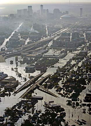
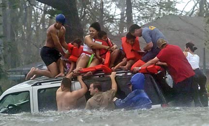
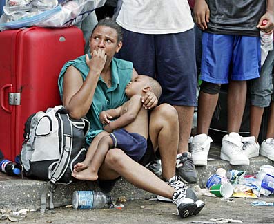
As Katrina so adroitly demonstrated, wind is not the greatest danger from a hurricane. Most deaths associated with hurricanes are from flooding, and most property damage results from storm surge.Storm surge is a mound of water that the wind pushes away from the center of the storm.
It creates a bowl-shaped depression in the sea surface as wide as the storm as it blows water. It is storm surge when it reaches the shore.
The storm surge combines with the daily tides, which can vary by several feet, depending on the location and the moon phase. In addition, there are large, wind-driven waves on the water.
Forecasting the storm surge is complicated. Its size also depends on the shape of the coastline, the slope of the sea floor near the coastline and the timing of the surge with respect to the normal high and low tides.
Katrina was an exceptionally large Category 5 storm that picked up huge amounts of energy from the 90-degree surface sea temperatures in the Gulf of Mexico. It created a storm surge up to 20 feet that was right in the middle of the range predicted by the computer models.
Katrina has been called a 500-year storm, which means that a storm of that size and ferocity occurs on the average only once in 500 years.
Probability does not in any way mean that there can not be another one of equal strength next year, or even again this year.
September is the month of maximum hurricane activity in the Atlantic, and the season extends well into November.
Let us hope beyond hope that Katrina is the last one for 500 years or more.
More information
Answers to just about any question you might have about hurricanes is online at the NOAA Hurricane Research Center's FAQ (www.aoml.noaa.gov/hrd/tcfaq/tcfaqHED.html).
E-mail to Business Desk
[News] [Business] [Features] [Sports] [Editorial] [Do It Electric!]
[Classified Ads] [Search] [Subscribe] [Info] [Letter to Editor]
[Feedback]