
Radar helps detect
changes in Mauna Loa
Geologist Michael Poland’s
work gives a better picture
of the volcano's buildup
HILO » Hawaiian Volcano Observatory geologist Michael Poland is looking at Mauna Loa from space with radar. The images he uses will give a better picture as the mountain builds toward its next eruption.
In 2002, observatory scientists announced that Mauna Loa was slowly swelling with magma. The process will eventually lead to an eruption, but the buildup could go on for years, they said.
To keep tabs on Mauna Loa, observatory geologists and University of Hawaii scientists have placed a maze of instruments on the mountain, including 23 global positioning stations and 23 seismometers.
Those instruments are extremely accurate, but using them to view the mountain is like drawing a picture of someone's face by connecting dots. A photograph is a lot better.
Radar images showing an area 60-by-60 miles are available from Canadian and European space agencies, Poland said. The United States does not have a satellite to do that, he said.
Until Poland arrived on the Big Island in February, the observatory didn't have anyone who could interpret the images.
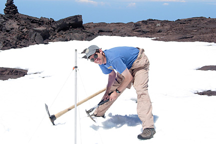
Hawaiian Volcano Observatory geophysicist Michael Poland prepared to take a reading of the degree of ground tilt caused by magma inside Mauna Loa during a recent trip to the summit. Poland will also use radar images to measure bulging of the mountain.
"It's tough to leave right in the middle of an eruption," he said of his move to Hawaii. But he added, "Very few people get to work on a Hawaiian eruption."
The lure is how much the ground moves in Hawaii, he said. At Medicine Lake Volcano in Northern California, ground sank about 3/8 of an inch in a year, he said. On Mauna Loa, the summit has stretched 15 times as much since last summer.
Scientists didn't even know the ground near South Sister volcano in Oregon had been inflating with magma until radar revealed it.
The technique takes two radar images, usually made a month apart, and uses a computer to subtract everything in the two that is the same, thereby revealing what has changed, he said.
The problem, said geologist Ben Brooks at the University of Hawaii, is that water vapor can give a false picture of the changes. Brooks is working on techniques to subtract the effects of water vapor.
With an accurate picture of changes in the surface of Mauna Loa, geologists can use computers to estimate what magma is doing below the surface.
"We're able to see things we were never able to see before," Poland said. But since radar images are available only once a month, the technique will only show the mid-term buildup toward an eruption, he said. Other instruments will track the final hours before an eruption.
E-mail to City Desk
[News] [Business] [Features] [Sports] [Editorial] [Do It Electric!]
[Classified Ads] [Search] [Subscribe] [Info] [Letter to Editor]
[Feedback]