
Researchers try to
map out Hawaii’s
cataclysmic future
Tsunamis are inevitable
in the islands but there's
usually plenty of warning
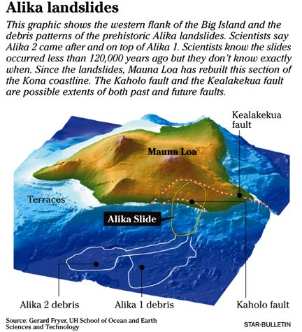
On a map of the Big Island, Gerard Fryer can put his finger on the place where Hawaii as we know it stands to change forever.
In South Kona, between Kealakekua Bay and South Point, the coast arcs westward from Mauna Loa's southwest rift zone.
Around 120,000 years ago, says Fryer, the coastal shelf collapsed into the ocean, creating a cataclysmic megatsunami that washed over the Hawaiian Islands, penetrating up to four miles inland and a third of a mile high.
In the intervening millennia, says the University of Hawaii geophysicist, the coastline has built back up and is ripe for a repeat.
That doesn't mean it will happen tomorrow, or next year, or even next century.
"Those things happen few and far between, but we cannot ignore them because when they do happen they are so catastrophic that they are sort of culture-ending disasters," says Fryer. "I am pretty much convinced that if there would be a big landslide like that, there would be abundant warning. There would be lots of little earthquakes, and it should be pretty well defined. I think there would be months or even years of warning. But it would still be a catastrophe."
Large-scale disasters that happen very seldom -- known to emergency planners as "low-frequency, high-impact events" -- have taken on new interest and urgency in the aftermath of the Dec. 26 Indian Ocean tsunamis.
Several deadly seismic waves have hit Hawaii in recorded history, but none since 1975, when waves from a magnitude-7.2 quake on the Big Island washed out a Boy Scout camp, killing two people.
Given that Hawaii was hit by tsunamis in 1933, 1946, 1952, 1957, 1960 and 1964, the last 30 years represent a lengthy break from destructive waves.
How high should they rank on the worry scale?
Compared with geologically active areas around the Pacific's notorious Ring of Fire, Hawaii rests in relative stability. From just north of Molokai, a crack in the seabed known as the Molokai Fracture Zone runs nearly all the way to the seismic hot zone of the eastern Pacific, famous for the San Andreas Fault.
The Molokai Fracture Zone could have been the source of a magnitude-7 earthquake near Lanai in 1871, which was felt on Oahu, and another on Maui in 1938, says Fryer. Honolulu also was shaken by a 4.8-magnitude offshore quake in 1948.
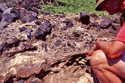
On the Kohala coast of the Big Island, David Tappin of the British Geological Survey points to the contact between the tsunami deposit above, and older rock below. The tsunami deposit is made up of broken and smashed marine fossils mixed in with chunks of basalt lava. Coral fragments in the deposit are 120,000 years old.
Maui County buildings, in zone 2B, have slightly higher risk, while the Big Island is classified as a seismic zone 4.
Mauna Loa and Kilauea volcanoes are the chief source of seismic risk on the Big Island, where numerous "microquakes" -- too small at magnitude 1, 2 and 3 to be felt -- occur every week. Click on the Hawaii map at earthquake.usgs.gov and you can see that most occur in Hawaii Volcanoes National Park.
But quakes equal to or greater than the one in 1975 remain a possibility -- in fact, over time, a geological certainty, scientists say.
"Mauna Loa is the 800-pound gorilla," says Fryer. "That is the one that keeps us up at night -- the possibility of a big earthquake along the Kona Coast of the Big Island."
In 1868 an earthquake killed 79 people on the Big Island -- 47 from a tsunami, 31 from a landslide and one from a rockfall.
A quake with killer-tsunami potential would be unmistakable to residents in Kona, says Fryer.
"On the Kona Coast, people would be shaken very severely. It's not something they could ignore. They would have difficulty standing. That would be the signal for them to move inland."
The quake would register almost immediately on the instruments at the Pacific Tsunami Warning Center in Ewa Beach. But every quake does not a tsunami make.
The scientists there would be looking at tide gauges along the coast of the Big Island to determine how much water is on the move. By the time a tsunami has been confirmed and Civil Defense sirens blare, Honolulu beachgoers might have 20 minutes to get to safe ground. That's enough if they don't delay.
Coastal residents don't have "time to feed the cat or look for the dog or something," says Fryer. "You gotta get out."
The system can be improved with sensors that report via instantaneous communications links, says Fryer.
Continued improvements are the stated goal of the National Oceanic and Atmospheric Administration, which runs the warning center and is working toward greater international cooperation.
"The nations of the world already spend billions of dollars on earth observation," said NOAA Administrator Conrad Lautenbacher during a visit this month. "So the first thing to do is try to gain the synergy of connecting those systems together with ground-based systems and provide comprehensive coverage and share this data on a real-time basis."
The good news is that Hawaii has greatly increased its preparedness for tsunamis that originate in far-off places. Though seismic waves travel at jet-airliner speeds in the open ocean, they still take five or six hours to get here from the Aleutian Islands or Chile.
That gives the warning center time to look at readings from its wave-sensing sea-floor buoys and quick-reporting coastal tide gauges to determine if a destructive wave is on the way. Such buoys and gauges are absent from the Indian Ocean, where nations now have a strong incentive to install them.
www.pgd.hawaii.edu
Pacific Tsunami Warning Center
www.prh.noaa.gov/ptwc/
State Civil Defense
www.scd.state.hi.us/
Pacific Tsunami Museum
www.tsunami.org/
[News] [Business] [Features] [Sports] [Editorial] [Do It Electric!]
[Classified Ads] [Search] [Subscribe] [Info] [Letter to Editor]
[Feedback]