

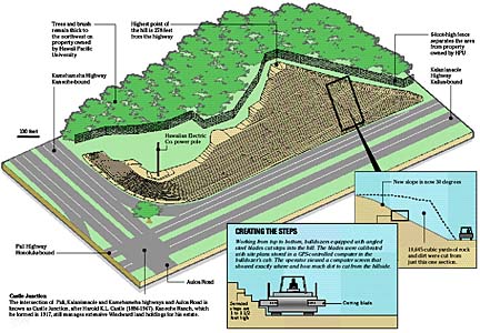
The 10-month, $7.8 million project to restructure the hill at Castle Junction is nearly complete. About 250,000 cubic yards of dirt were removed to stabilize the hill so rocks and dirt would not fall on the road below. That's 18,000 dump-truck loads of earth.
The Castle Junction hill-trimming that began in January is largely complete, although restoration of a right-turn lane that is part of the project will take until November. Last week, the last bit of 250,000 cubic yards of dirt was removed in what has been called the state Department of Transportation's largest-ever remake of a roadside feature.
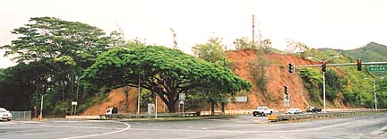
BEFORE: A potential danger to traffic
|
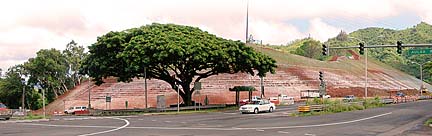
AFTER: A safer roadway
|
The $7.8 million project was put on an emergency fast track after a mudslide onto the highway in May 2003, followed by more slides in December.
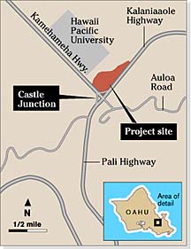
The intersection of Pali, Kalanianaole and Kamehameha highways on Oahu's Windward side had earlier been identified as one of the 10 most dangerous rockfall hazards along state highways.
Vertical slopes of up to 70 degrees on the Hawaii Pacific University corner of the intersection have been trimmed to about a 30 percent slope, with stair-step terraces that will be landscaped with grass.
The white stuff you see on the hillside now is lime that is being used as a soil enhancement, said Arthur Lambert, Oahu regional manager for contractor Goodfellow Brothers.
|
 |
Much of the "stacking" lane had been out of use for some time, buried under rocks and dirt.
The 12-foot-wide lane will be repaved and an 8-foot shoulder and new drainage gutters added, Ishikawa said.
The project was originally slated to be complete in mid-July, but major rain delays slowed progress, Lambert said.
Despite the downtime, he is pleased with the final result.
"I think it looks like a side to one of the pyramids in Egypt," Lambert said. "I think it's a very unique job."
Top 10 hazardous areas
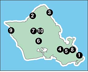 |
1. Kalanianaole Highway at Makapuu
2. Kamehameha Highway near Waimea Bay
3. Kamehameha Highway near Kahuku
4. Kalanianaole Highway, Kailua-bound near Castle Junction
5. Kalanianaole Highway, Kaneohe side at Castle Junction
6. Kamehameha Highway near Kipapa Gulch Bridge
7. Kamehameha Highway near Wahiawa
8. Kailua Road just before Kailua town
9. Farrington Highway before Yokohama Bay
10. Kamehameha Highway near Wahiawa