
|
Facts of the Matter Richard Brill |
STAR-BULLETIN / 2002
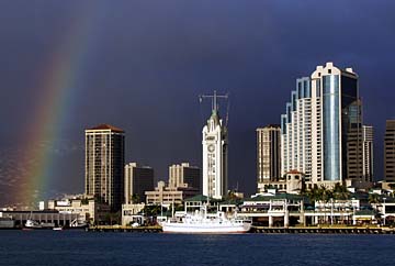
Complex forces combine to present a majestic masterpiece in the skies. But a lot of it can be as simple as the "sweat" on a glass.
Water cycle
keeps it all movingOne thing that characterizes our home planet and makes it unique is it abundance of liquid water. Even more distinguishing is Earth's hydrologic cycle, whereby water cycles through planetary reservoirs of ocean, atmosphere and land through evaporation, precipitation and runoff.
Everyone knows that rain falls (precipitates) from clouds and eventually flows back into the sea (through runoff or percolation through the ground). Understanding why clouds form, and why at some times and places and not others, is less common knowledge but easy to understand.
Clouds of all shapes and sizes are made of microscopic droplets of water or ice crystals that have condensed from water vapor.
Air is a mixture of gases, mostly oxygen and nitrogen, with smaller amounts of argon and carbon dioxide, and trace amounts of numerous other gases, salt crystals and dust particles. Those minute dust particles and salt crystals play a major role. Without them clouds might not form at all, or at least would be much rarer and would require much lower air temperatures.
The most variable component of air and the third most abundant is water vapor -- invisible, unattached molecules of water dissolved in air like sugar dissolved in water.
Water is an unusual substance in its own right. A water molecule consists of two hydrogen atoms attached to one side of a much larger oxygen atom, leaving an unequal distribution of electrical charge that makes water molecules slightly sticky.
The stickiness of water molecules keeps water liquid at higher temperatures than other lightweight molecules such as oxygen and nitrogen.
Air pressure affects the ability of water molecules to escape from the surface of liquid water or ice, requiring a higher temperature (more thermal energy) to escape the higher the pressure.
The pressure of Earth's atmosphere is due to the combined effects of gravity, which keeps the rapidly moving air molecules from flying off into space, and the thermal motion of air molecules.
The molecules of any gas are in constant, rapid and random motion, and their speed depends on the temperature.
At 75 degrees Fahrenheit, a typical air molecule is moving at more than 1,100 miles per hour. Of course it doesn't travel more than a few molecular diameters before it collides with another molecule, so we don't perceive the collisions with our skin as wind because the motion is random and equally distributed in all directions. We perceive it as temperature and measure the force of the collisions as air pressure.
Not all molecules are moving at the same speed. There is a statistical distribution of speeds that resembles a bell curve, so that at any temperature there are always a few molecules that are moving fast enough to escape the electrical attractions of neighboring molecules. When that happens we say evaporation has occurred.
The amount of water vapor that the air can contain depends almost entirely on the temperature of the air because thermal agitation of water molecules in their gaseous form inhibits them from sticking together to condense into the liquid state.
When the concentration of water molecules becomes sufficiently dense that the air can hold no more, the air is "saturated," also known as 100 percent relative humidity.
Relative humidity (RH) is a comparison of the amount of water vapor in the air with the amount at saturation for a given temperature, usually expressed as percent.
When we speak of "moist" or "dry" air, it is referring to the relative humidity of the air rather than the total amount of water vapor it contains. Moist tropical air might have a RH of 60 percent or more, while dry desert air would typically be at 10 percent RH.
RH influences evaporation, since dry air has a greater capacity for water vapor than moist air. RH is also directly related to dew point, the temperature at which a particular volume of air would become saturated (when its RH would be 100 percent). One way to measure dew point is to add ice slowly to a metallic cup of water and note the temperature at which "sweat" first appears on the outside of the cup.
As with the "sweating" cup, water vapor condenses more readily when there is a surface on which to condense. In the atmosphere those microscopic grains of dust and salt serve the purpose, acting as condensation nuclei.
Microscopic dust particles have a slight surface electric charge that attracts the sticky water molecules (the smaller the particle, the greater the charge), and salt naturally attracts water vapor, as evidenced by the solid mass in the salt shaker on the kitchen table in humid climates.
Water will begin to condense around the microparticles well below 100 percent RH, making the atmosphere hazy when the RH is 75 percent or so.
Now it should be easy to see the two conditions that are necessary for clouds to form: Air must be cooled below its dew point, and there must be microparticles to act as condensation nuclei.
Clouds are formed by rising air that encounters lower pressure, expands and cools. Clouds delineate places where air has cooled below its dew point as it was moved upward by any of several means.
One way air is uplifted is when surface wind encounters a mountain range. On the windward side of a mountain range, clouds build up as the surface wind flows up and over causing heavier rainfall on the windward side. This happens on a volcanic island such as Oahu as well as on a continental mountain range, such as in the Pacific Northwest. Having dumped some of its moisture, air and the resulting climate are drier on the leeward side of the mountains.
Another way air is uplifted is when the sun heats one part of the surface more strongly than another due to differences in the color, texture or material of the surface. This effect can range in size scale from small thermals that birds use for soaring, to global-size masses of air that drive the prevailing winds such as the trades and the westerlies.
On another scale, unequal heating causes land and sea breezes, blowing up the mountain in the daytime and down the mountain at night. Even on windless days this might cause clouds to build up over the mountains only to sag back downward as if posing for a Maxfield Parrish painting as the sun sets.
On a continental scale, unequal heating is responsible for summer monsoons as the rising air above a large land mass pulls moist air inland from the sea. On a smaller scale, it is the source of the almost daily rainfall that nourishes the Kona slopes of Mauna Loa and the coffee industry that thrives there.
Much of Earth's weather, including some of the rain and thunderstorms that have darkened Hawaii's daytime skies and lit up the night this winter, is the result of the interaction between huge masses of air that are relatively uniform in temperature and RH over hundreds or thousands of miles.
There are basically four types of air masses, reflecting the temperature and humidity that characterize the regions where the air masses form. As a rule of thumb, temperature reflects the latitude north or south, while the humidity reflects whether the air mass formed over the ocean (maritime-moist) or over land (continental-dry).
The four types are the possible combinations of cold or warm temperature with moist or dry air: warm and dry, cold and dry, warm and moist, cold and moist.
If Earth did not rotate, and there were no seasonal shifts in the sun's location north and south of the equator, weather would be predictable and boring.
But it is not boring because the sun heats Earth's surface more intensely the nearer to the equator, causing a global circulation and pressure center. Those air masses don't stay in one place. They migrate north and south seasonally and move eastward and westward in the prevailing winds as Earth's rotation deflects the air into swirling patterns and vertical movements exchange air between the surface and eight or so miles upward.
When two contrasting air masses interact, clouds form at the boundary as cold air, being more dense, wedges under warm air, causing it to rise along a "front" that might be several hundred miles wide and several thousand miles long.
If the moving mass is a cold one, the front (a cold front) is steep, the uplift rapid, and the result can be violent thunderstorms and tornadoes. If the moving mass is warm, the front (a warm front) is a gently sloping wedge, the uplift is slower and the result is a slate sky with drizzle to light showers.
There are other complications, of course, otherwise the weather would be much more predictable than it is. One important complication is that evaporation and condensation of water involves huge amounts of heat, which can produce positive feedback to keep storms raging for days or weeks, as in the case of hurricanes and other tropical cyclones.
Another complicating factor are the jet streams, which whip around the earth high in the atmosphere, influencing the movement of air masses, their respective fronts and associated pressure centers.
Another is that there are multiple layers of air which might have different temperature and humidity characteristics from the layers above and below them, and might either foster or inhibit vertical movement of air. Some weather might occur in layers above the surface, such as the upper-level disturbance that lingered over Hawaii in February and early March this year.
Although the basic principles underlying cloud formation and weather in general are fairly simple, weather is an excellent example of how complexity can be generated from simplicity, and another fascinating aspect of our remarkable and unique planet.
But like everyone else, it seems I've been doing a lot of talking about the weather but have done absolutely nothing about it!
Richard Brill picks up where your high school science teacher left off. He is a professor of science at Honolulu Community College, where he teaches earth and physical science and investigates life and the universe. He can be contacted by e-mail at rickb@hcc.hawaii.edu