U.S. GEOLOGICAL SURVEY
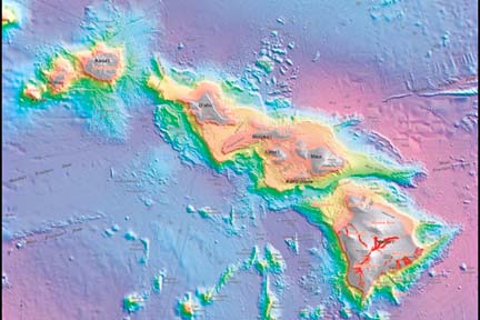
The depth to the sea bottom is indicated by color shading. The topography of the islands is in gray shades. Lava flows are shown in red from Hualalai, Mauna Loa and Kilauea volcanoes, from the earliest written records through past summer. The blocky debris fields reflect underwater landslides that broke off volcanoes in the past. Submerged terraces surrounding islands are shown in orange and yellow, reflecting the sinking of islands.
Ocean floor a busy picture
in new topographical mapNew technology helps the four-year
project speed up completion
The topography of Hawaii's sea floor and islands from Niihau to the Big Island is shown in the first map of its kind, just published by the U.S. Geological Survey.
The USGS Hawaiian Volcano Observatory says it is a "stunning" map, showing all prominent geological features of the sea floor in color, including landslides, seamounts, fracture zones and volcano fields. They are illuminated from the northeast to show sea-floor relief.
Collaborating with the USGS in the project were the Japan Marine Science and Technology Center, the University of Hawaii and the Monterey Bay Aquarium and Research Institute.
John Smith Jr., Hawaii Undersea Research Laboratory researcher, said he and Terri Duennebier, data manager in the UH School of Ocean and Earth Science and Technology, began assembling mapping data 12 years ago. "Others started adding to it," Smith said.
The Japan center led a four-year survey of the underwater flanks of Hawaii's shield volcanoes, involving scientists from the other academic and research institutions. They used manned submersibles, robotic vehicles and other specialized equipment to sample and observe the ocean bottom at specific sites.
"When Terri and I started this, there wasn't much of this multibeam sea data or high-resolution mapping systems," Smith said. "There was only some data around the Big Island that kind of got filled in."
Ocean floor mapping began taking off about 1998 with development of high-resolution sonar systems used on ships to map ocean depths from the sea surface, he said.
Smith, who was involved in the Japan center's survey and other cruises, said they were able to cover parts of all islands with the map, but they are still adding to the data.
They continue to find surprises, he said. "There are always features we look at in nautical charts or low-resolution data that look kind of smooth and sometimes boring and featureless. When we map with high-resolution systems, volcanic features jump out, with ridges and volcanic cones we didn't expect or show up strikingly."
Rift zones that appear in low relief on land "under water come alive," he said. "We can do more science, more geology, than we could do before. ... This is kind of the first step."
It took a long time to create the map because much of it was done while doing other research, and a lot of it was technology-driven, he said. "These systems have improved, and a lot of them weren't possible or developed 10 years ago."
All lava flow eruptions since written records were kept through the past summer are portrayed from Hualalai, Mauna Loa and Kilauea volcanoes.
"A viewer of the map is immediately impressed with how 'busy' the sea floor is next to the islands," the Volcano Observatory said.
"Fields of blocky debris indicate the presence of underwater landslides that peeled off the volcanoes in the past, most recently about 100,000 years ago from part of the Kona coast."
Smith said, "Multibeam mapping has been a real eye-opener for the detail of submarine landslides." He said they were able to study landslides for all islands in detail, especially the Big Island.
Oahu's Nuuanu Slide, the largest, broke off the Koolau Range and is shown extending about 120 miles from the Pali. It is joined by the Wailau Slide, which carried away the north side of Molokai before Kalaupapa was formed.
Smith said a couple of big slides north and south of Kauai have not been fully mapped yet, but the South Kauai Slide reaches almost 60 miles southeastward from the island.
Prominent submerged terraces surround most of the islands, reflecting sinking of the islands. Submarine rift zones, past sites and those of the future at Kilauea Volcano appear on the map.
Most striking, the Volcano Observatory noted, is the Hana Ridge, reaching nearly 80 miles east of Hana. It ends at a depth of 16,000 feet with "two curious sharp ridges that resemble a gaping, Pac-Man-like mouth."