Storm spirals
near Big IsleHurricane Jimena, with
105 mph winds, may pass
south of the island tomorrow
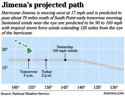
Big Island residents are urged to prepare for possible strong winds, high surf and flooding if Hurricane Jimena sticks to a route passing about 70 miles south of South Point early tomorrow morning.
A hurricane watch and a tropical storm warning were issued for the Big Island yesterday afternoon, cautioning residents that hurricane conditions were possible within 36 hours and tropical storm conditions are likely within 24 hours.
The hurricane's center was about 585 miles east-southeast of Hilo at 8 p.m. yesterday, moving almost due west at about 17 mph, the Central Pacific Hurricane Center in Honolulu reported. Maximum sustained winds were near 105 mph, with higher gusts.
The hurricane was reported "wobbling along its track" late yesterday. "It's not traveling straight and true. It's wobbling like a little kid riding a bike," said forecaster Jeff Powell. But it was still on track, he said.
Three Air Force "Hurricane Hunter" planes were to penetrate the hurricane this morning en route from California, said Tim Craig, National Weather Service lead forecaster. The planes will remain in the Central Pacific, gathering meteorological information until the storm passes, he said.
Hurricane-force winds (75 mph or more) extend about 30 miles from the eye of the storm, Craig said. Tropical storm winds extend up to 90 miles from the eye.
Kevin Kodama, another National Weather Service lead forecaster, said Jimena was not expected to have much effect on the weather on Oahu and the other islands.
"It's a rather small storm, with effects mainly confined to the Big Island," he said.
Based on the current path, Kodama said the Big Island will get tropical storm-force winds of about 40 mph with gusts to 60 mph. The winds will hit southern parts of the island starting tonight.
Heavy rains could soak the Big Island's southern area with 4 to 6 inches or up to 10 inches in local spots. Flooding is possible in low-lying or poor drainage areas.
Jimena barely qualifies as a category 2 hurricane, compared with Hurricane Iniki, Powell said. Iniki, which devastated Kauai in September 1992, was a borderline category 5 hurricane with powerful sustained winds up to 150 mph.
Jimena is slower, not as strong, and moving from east to west instead of south to north as Iniki did across Kauai, Powell said.
Although the Big Island is expected to bear the brunt of Jimena, Kodama said errors can occur in the track forecast.
"Any type of jog to the north, even a few tenths of a degree, a few miles, make a difference," he said.
A high-surf advisory was in effect yesterday for east and southeast-facing shores of Maui and the Big Island. Surf heights of 8 to 12 feet at full face values were predicted by mid-morning today, with occasional higher sets.
As a precaution, beach parks in the Kau and Puna districts were closed, according to the Hawaii County Civil Defense Agency. High tide up to 3.2 feet will occur at 6:05 p.m. today and 7:34 a.m. tomorrow at Honuapo on the southeast coast of the Big Island, it said.
Despite the warnings, surfers on Oahu were looking forward to a "hurricane swell."
Billy Kaczynski, Vino Indalecio and Mara Estomago said they hope Jimena comes close enough to Oahu to bring some high surf, but not close enough to bring wind that will make for "junk" conditions.
"People have different reactions to hurricanes," said Jim Garland as he headed out from Magic Island yesterday afternoon. "For all surfers, when you hear about a hurricane, that means waves coming."
Oahu residents generally didn't appear to be concerned about the hurricane yesterday, even in Waianae, which suffered effects of Iniki.
"It's quiet over here," said Tae Kwak, owner of the Waianae Market on Farrington Highway.
Gayle Kam, manager of Times Super Market in Waipahu, said: "I haven't had any indication of any panic or anything. I think they're concerned more about the bus strike.
"I guess as it gets closer, nowadays stores are open 24 years, and they think they can just run over."
Most shoppers at the Iwilei Costco yesterday afternoon said they were stocking up for Labor Day barbecues rather than for the hurricane.
Kapalama Heights resident Eldon Matsuura, who was left homeless after Hurricane Iwa hit Kauai in 1982, bought three cases of bottled water, a box of nectarines and toilet paper.
"I know how it feels. I still remember all that," he said. Iwa destroyed his Kapaa Meadow home on Kauai when a neighbor's roof slammed into his house.
"I spent three months in a hotel after Iwa. Then I sold my house cheap and got outta there," he said.
If a hurricane hits Honolulu, Matsuura said, "It's gonna be dog-eat-dog, 'cause there are too many people here."
Star-Bulletin reporters Elizabeth Fong and Diana Leone and the Associated Press contributed to this article.
BACK TO TOP |
Be prepared for coming storms
Gather the following supplies for your hurricane survival kit before a storm strikes:>> Nonperishable food (three-day minimum supply)
>> Drinking water (minimum two quarts a person a day)
>> Extra prescription medications
>> Battery-powered radio and/or TV
>> Flashlights or lanterns
>> Extra batteries
>> Manual can opener
>> Disposable plates, cups and utensils
>> Disposable washcloths and towels
>> First-aid kit and water purification kit
>> Ice chest and ice
>> Matches
>> Nonelectric clock
>> Toiletries
>> Plastic drop cloth
>> Fuel can and fuel for stoves, hibachis, lanterns
>> Fire extinguisher
>> Cellular phone with extra batteries
>> Portable generator
>> Extension cords
>> Latex gloves
>> Tool kit
>> Sunscreen
>> Extra clothes, eyeglasses
>> Extra cash
>> Insect repellent
>> Books, magazines, toys, cards and games for entertainment
>> Important papers (insurance policies, bank account numbers, family contacts, medical information)
>> Pet food
>> Pillows, blankets, sleeping bags, air mattresses
>> Masking tape for windows and glass doors
Before and during a hurricane
>> Even if a hurricane doesn't hit, you should have an emergency plan. If you plan to evacuate, your plan should include where you will go, the route to get there, when you will leave and what to take with you, and what preparations you will make to your home. If you plan to stay, make sure that you have all of the supplies necessary to be on your own for at least 72 hours. If you are planning to go to an evacuation shelter, have your shelter supplies kit packed and ready.>> Make sure that you have all the materials on hand to protect your home and that you prepare your home no later than when a hurricane warning is issued.
>> You should also trim dead wood and limbs from your trees. Don't forget to make arrangements for your pets.
>> Fuel your vehicle.
>> Bring in outdoor objects such as lawn furniture and toys.
>> Install your storm shutters or plywood and secure all doors.
>> Prepare boats as appropriate.
>> Turn up refrigerators and freezers to their coldest settings.
>> Turn off small appliances that are not needed.
>> If you evacuate, turn off your air conditioner. If you stay at home and the power goes off, turn off your air conditioner. Turn it back on only after power has been restored in your area.
>> Turn off all liquid propane tanks.
>> Fill sinks and bathtubs with water.
>> Get an extra supply of cash.
>> Call someone out of town to let them know of your plans. Then instruct other family members to call that person for information about you after the storm. It is usually easier for you to call out of the area after a storm than it is for others to call into the area.
>> Stay away from windows and doors, even if they are covered. Go to an interior first-floor section of the house such as a hallway, bathroom or closet.
>> Close all interior doors and brace exterior doors.
>> Lie on the floor, under a sturdy object.
>> If the eye of the storm passes over, it will be calm for a short period of time. Remain indoors. As soon as the eye passes, winds will increase rapidly from the opposite direction.
>> Remain calm. It may take several hours for the storm to pass.
After a hurricane
>> Drive only if it is absolutely necessary.>> Stay on firm ground. Moving water only 6 inches deep can sweep you off your feet. Standing water may also be electrically charged from downed power lines.
>> Beware of insects and animals driven to higher ground by flood waters.
>> Enter your home with extreme caution. Beware of fallen objects or damaged roofs and wall sections. Watch for nails, splinters, holes in walls or floors, wet or falling sections of ceiling, undermined foundations and gas leaks. Use flashlights for light. Do not use matches, torches or other open flame.
>> Remove shutters or plywood, and open windows and doors to ventilate or dry your home if necessary.
>> Check gas, water and electrical lines and appliances for damage. Do not attempt to repair gas or electrical lines. Call a professional.
>> Do not drink or prepare food with tap water until you are certain that it is not contaminated.
>> If your home has been flooded, flush plumbing fixtures with buckets of water to be sure they are open. Have health authorities inspect your sanitary disposal system. Water may have backed up into the septic tank, which in turn backs up into the plumbing system.
>> Avoid food that has come in contact with flood waters.
>> Start cleanup as soon as possible, especially if your home was flooded. Take pictures of all damage before you begin cleanup or repairs, for insurance purposes. Thoroughly dry and clean your house before trying to live in it.
>> Give special attention to cleaning children's toys, cribs, playpens and play equipment. Boil any items a toddler or baby might put in his mouth. Discard stuffed, waterlogged and noncleanable toys.
>> Wear protective clothing on legs, arms, feet and hands while cleaning up debris. Wear rubber gloves while scrubbing flood-damaged interiors and furniture.
>> Never connect portable generators to your house. Use them only to run the necessary appliances, and plug the appliance into the generator.
Classifications
Hurricanes are classified into five categories, based on their wind speeds and potential to cause damage.Category 1: Winds of 74-95 mph and storm surge 4 to 5 feet above normal. Damage limited to unanchored mobile homes and poorly constructed signs. Limited coastal road flooding and minor pier damage.
Category 2: Winds of 96-110 mph and storm surge generally 6 to 8 feet above normal. Roofing, door and window damage to buildings. Considerable damage to mobile homes, signs and piers. Coastal and low-lying areas may flood as the storm approaches land. Small craft in unprotected anchorages break moorings.
Category 3: Winds of 111-130 mph with storm surge 9 to 12 feet above normal. Some structural damage to homes. Mobile homes are destroyed. Coastal and low-lying escape routes will flood as the storm approaches the coast. Storm surge and waves will destroy coastal small structures.
Category 4: Winds 131-155 mph and storm surge of 13 to 18 feet. More extensive roof structure failure on buildings without proper anchoring and strapping. Complete destruction of mobile homes. Coastal and low-lying escape routes will flood as the storm approaches the coast. Storm surge will cause major damage to structures near the coast.
Category 5: Winds in excess of 155 mph and storm surge greater that 18 feet. Complete roof failure on many buildings. Some buildings destroyed. Coastal and low-lying areas will flood as the storm approaches the coast. Destruction of structures along the coast from storm surge and waves. Extensive damage to inland homes near the coast from floating debris.
Terms to know
Tropical storm: An organized system of strong thunderstorms with a defined circulation and maximum sustained winds of 39 to 73 mph.Tropical storm warning: It is issued when tropical storm conditions are expected within 24 hours.
Hurricane: An intense tropical weather system with a well-defined circulation and maximum sustained winds of 74 mph or higher. In the western Pacific, hurricanes are called "typhoons," and similar storms in the Indian Ocean are called "cyclones."
Hurricane watch: It is issued when there is a threat of hurricane conditions within 36 hours. Preliminary precautions should be taken.
Hurricane warning: It is issued when sustained winds of 74 mph or more are expected in a specified area in 24 hours or less. A hurricane warning can remain in effect when dangerously high water or high waves continue, even though winds may be less than 74 mph. Actions for protection of life and property should begin immediately when the warning is issued.