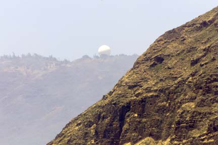
CINDY ELLEN RUSSELL / CRUSSELL@STARBULLETIN.COM
Smoke from a wildfire veiled the view of one of the radomes located on the Waianae Mountain Range just above Kaena Point.
Brush fire threatens
Air Force tracking siteFirefighters struggle
to stop a 1,700-acre
blaze near Kaena Point
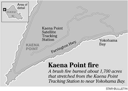
More than 100 firefighters and state workers battled a brush fire that scorched about 1,700 West Oahu acres and threatened the Air Force's Kaena Point Satellite Tracking Station yesterday.
No injuries were caused by the blaze, reported at 7:47 p.m. Friday and declared under control at 7:14 p.m. yesterday, said Honolulu Fire Capt. Emmit Kane.
The fire was in a valley next to Makua Valley, where a July brush fire burned more than 2,000 acres, enraging native Hawaiian activists and environmentalists. The Makua Military Reservation fire spread when a controlled burn of 500 acres by the Army was blown out of control by strong winds.
The cause of this weekend's fire has not been determined.
Kane said a stiff wind and plenty of dry brush made fighting the fire a challenge.
Campers at Yokohama Beach were evacuated by police, and the areas past the tracking station were checked for hikers or hunters, Kane said.
The fire was initially reported by a sentry at the gate at Kaena Point Tracking Station Friday night. The fire had been heading north, but overnight it shifted and jumped the access road.
Yesterday morning, the fire had burned the area on the mauka side of the road that runs parallel to Yokohama Bay. Firefighters contained the fire in that area and returned to the mauka area.
The environmental damage wasn't immediately known. The state-owned region, called by its Hawaiian name Keawaula, includes the Mokuleia and Kuaokala Forest Reserves and a game preserve managed by the state Department of Land and Natural Resources.
Paul Conry, DLNR wildlife program manager, said some bird colonies could be affected, depending how far west the fire spread. There are game bird populations in the management area, colonies of seabirds nesting along the upper edges of the cliff, nesting wedgetailed shearwaters and some albatross, he said.
"It's a prime area for bird and pig hunting," said Maj. Kevin Lackey, commander of the Air Force tracking station.
A biologist familiar with the area said endangered plants on the higher areas of the valley include akoko, nehe and a hibiscus called maohauhele.
Kane said there was minimal impact to the forest reserves, but a DLNR official had told him about 10 to 20 acres in one reserve had burned, possibly threatening endangered species. An assessment was planned for this morning.
The only structures in the area belong to the Air Force station, which has 16 facilities at Kaena Point on 153 acres leased from the state.
"The fire was on both sides of our access road from sea level up to the mountains," Lackey said.
The Honolulu Police Department blocked off Farrington Highway and closed the three-mile switchback access road to the station early yesterday, he said.
The flames came within 300 feet of one of the station's large antennas, he said. "The top priority was to keep those facilities from burning and making sure the personnel was safe."
Lackey said he could not say how many people were there yesterday, but about 75 are assigned to the site every month. No personnel was evacuated, he said.
Twenty Honolulu Fire Department companies with about 65 firefighters, including five tankers and its helicopter, six federal fire companies with 20 firefighters, 10 to 15 DLNR forestry and wildlife officers and several units from the Hickam Air Force Base Fire Department battled the blaze, Lackey said.
Four helicopters from the Hawaii National Guard, the Army's 25th Infantry Division and the Federal Fire Department dropped water on the fire.
Lackey said the firefighters were able to keep the blaze away from the station, then focused efforts on the Makua side.
"This fire was not started by the Air Force," Lackey noted. "It was reported by the Air Force when we saw flames coming into the control point (Friday evening) at the beginning of our access road."
Flames were shooting up the hill, he said.
"I was up there at the top at the time this was happening. The flames got very close to the facilities. You could smell it but nobody got injured. Fortunately, the winds were blowing toward the ocean, away from our facility."
The tracking station also has good fire breaks around the buildings, he said.
There are two water tanks at the site, each capable of holding 25,000 gallons of water. Firefighters drove their vehicles up without water and filled them at the station, which pumps water from the Dillingham side, Lackey said.
A fire in 1998 at Yokohama Bay was much larger, he said, resulting in the temporary closure of Yokohama Beach and the Kuaokala Forest Reserve and Game Management Area.