Mauna Loa’s
lava flow mappedThe Hawaii Volcano Observatory offers
a more accurate picture of where lava will go
HILO >> When lava from Mauna Loa headed toward Hilo in 1984, residents saw it dozens of miles uphill but had no idea where it would hit. Fortunately, it stopped after three weeks and hit nothing.
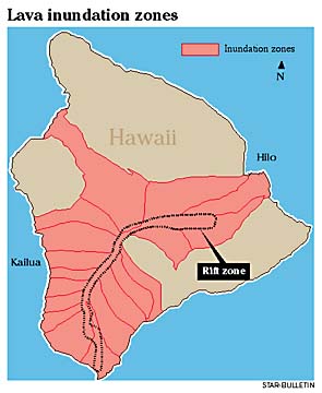
Now the Hawaiian Volcano Observatory has created new "lava inundation" maps of Mauna Loa, which give much more accurate pictures of where lava will go.
The maps only show where the flows would go. They tell nothing about when they might occur.
Last summer, the observatory said the mountain was swelling slightly with magma, suggesting a possible eruption in the future. Since then the swelling has slowed.
Even before that the observatory's Mauna Loa specialist, Frank Trusdell, had begun work on the new maps to help Civil Defense and others make best use of their staffing during flows.
The Hawaiian Volcano Observatory has prepared a new map showing 18 "lava inundation zones" on Mauna Loa, plus the rift zone where most eruptions start. Studying Mauna Loa flows as much as 20,000 years old, geologists discovered that lava flows tend to stay in a given zone once they enter it. That means people in other zones can be assured they are safe. The other four mountains on the island have not been zoned.
For example, the maps show that a flow headed toward Hilo's Kaumana area on the north side of town is likely to stay on the north side, Trusdell said. There is no need to post staff in Waiakea on the south side.
Trusdell began by looking at previous maps of Mauna Loa flows, some of them 20,000 years old. He discovered that flows fell into 18 distinct zones.
That is a lot more detail than the islandwide map showing nine "hazard zones," published since 1974. Only four of the nine zones apply to Mauna Loa.
Despite the word "inundation" in the new maps, any new flow would snake through one of the zones but would not flood it, Trusdell said.
Also, most flows start in a long rift zone extending from an area above Hilo through Mauna Loa's summit to South Point. Predictions are only valid once a flow gets out of the rift and into an inundation zone, Trusdell said.
The new maps were distributed to Hawaii County Civil Defense and others at the beginning of the year. "This will be a nice tool," said Mayor Harry Kim, former Civil Defense head.
Others wanted the maps, including Kaumana School, Trusdell said. The school was in the potential path of lava in 1984.
The Ocean View community association also wanted the maps, he said. One corner of the community extends into Mauna Loa's southwest rift zone.
The maps can be viewed on the Internet at geopubs.wr.usgs.gov/docs/wrgis/mf-map.html or can be ordered at rmmcweb.cr.usgs.gov/public/mod.
Hawaiian Volcano Observatory