|
Creation’s caldron HAWAIIAN VOLCANO OBSERVATORY, Hawaii >> Twenty years of eruptions on Kilauea Volcano's east rift have greatly expanded scientific understanding, says geologist Tom Wright.
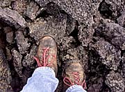
Kilauea's immense, enduring display
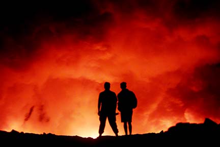
Fright and delight
expands the horizons of science
Volcano glossaryBy Rod Thompson
rthompson@starbulletin.com"It has been extraordinarily scientifically productive because you could see so many things so clearly for such a long time," said Wright, head of the Hawaiian Volcano Observatory from 1984-1991.
Scientists gained a detailed understanding of how pahoehoe lava moves, he said. The movement includes the creation of spots in a flow that bulge like a balloon before bursting open and starting a secondary flow.
They discovered shallow surface "intrusions" of lava. Scientists already knew about intrusions deep underground, where magma moves as if preparing for an eruption but never breaks through the surface.
At Kupaianaha lava pond, scientists discovered the process also happens near the surface, with lava leaking into recently deposited layers of rock, sometimes breaking out again elsewhere.
The formation of Puu Oo cinder cone, once 837 feet high, was another discovery. It was too tall, Wright said, twice as high as older cones on the rift.
In time, scientists saw the top crumble away, so that Puu Oo now resembles other cones.
"It was a genuine geological process observed in real time, in human time," Wright said.
|
By the beginning of January 1983, scientists knew something was up. Instruments had shown the intrusion of magma under the east rift. At 12:31 a.m. on Jan. 3, lava pushed to the surface along a series of cracks, eventually extending five miles.In the middle of the night, observatory photographer Jim Griggs got a call to jump aboard a twin-rotor military helicopter, along with staff geologists, and head nine miles downrift to the outbreak at Napau Crater.
"It was totally pitch black," Griggs said, but finally he saw fountains in the distance. Griggs could see they were no more than tree height, about 50 feet. The fountains were building piles of lava called "spatter ramparts" and had not yet formed lava flows.
The eruption settled into brief, nearly monthly "episodes" of fountaining, usually lasting less than a day.
For three years, in Episodes 4 through 47, the eruption centered at Puu Oo with lava fountains that eventually reached 1,540 feet.
In 1983-84, 16 homes were destroyed in Royal Gardens and neighboring Kapaahu, a relatively small number compared to the eventual 182 houses destroyed.
The observatory's second-in-command, Arnold Okamura, said damage was limited by style of the fountaining. High bursts in the air cooled the lava, turning it into slow-moving aa, and the short episodes meant not much lava was released.
In July 1986, a change in underground plumbing took place that scientists still don't understand. Fountains at Puu Oo stopped. At Kupaianaha lava pond, 1 1/2 miles downslope, flows without fountains started.
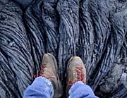
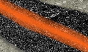
The new vent produced a different kind of lava flow, pahoehoe. Because pahoehoe is hotter than aa, it is more fluid. Because pahoehoe flows build insulating tubes, they retain their heat and flow great distances.
Scientists learned a lot about tube formation in 20 years, said geologist Jim Kauahikaua.
Types of lava
Aa >> The rough, chunky form a lava flow takes when it loses heat and gas and when crystal formation takes place.
Pahoehoe >> The smooth, fluid form a lava flow takes when it retains its heat and gas. Source: U.S. Geological Survey, Hawaiian Volcano Observatory
Pahoehoe flows start flat, but the top and the outer "wings" solidify, Kauahikaua said. Insulated by newly hardened rock around it, the center stays liquid and keeps flowing, he said.
To the surprise of scientists, the flow is hot enough to melt rock beneath it, so it cuts downward, making a channel, he said.
The result for residents downslope was destruction. Those tubes carried lava to homes, churches and a store in Kapaahu, Kalapana and Kaimu, from 1986-1990. A total of 189 buildings were destroyed.
Although lava flows are often compared to rivers, to area residents they seemed far less predictable than water.
"You can never call it with (volcano goddess) Pele," said former Royal Gardens resident Timothy "Oly" Kern. "She'll go where she wants to go."
Kauahikaua said that lava flows downhill.
Doing a computer study with contour maps, Kauahikaua created an islandwide map of "lava-sheds," comparable to watersheds. If lava is in one lava-shed, it will stay there flowing downhill unless something forces it into a neighboring lava-shed, Kauahikaua said. Then it will go downhill again.
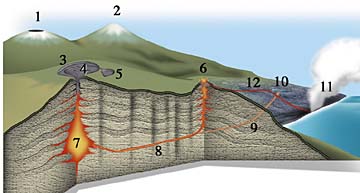
The lava tube
|
In 1992, Kupaianaha's plumbing got plugged. The eruption moved back to Puu Oo, but without the high fountains of the early 1980s. Why no fountains? Again, scientists aren't sure.Scientists see a bigger picture, in which the stage for this long-running eruption was set on Nov. 29, 1975, when a huge 7.2 magnitude earthquake split open the south side of Kilauea. Dozens of square miles of land slid seaward by as much as 30 feet. Countless cracks opened below the surface, providing space for magma to move easily, observatory chief Don Swanson said.
Former observatory head Wright said, "I firmly believe that the continuity of the current eruption has a lot to do with the opening of the rift zone by the 1975 earthquake."
BACK TO TOP |
Bench / delta >> An area of new rock at the edge of the sea, often several acres in size, which rests on loose sand and rubble. Glossary
Cone >> A pile of erupted material surrounding a vent. Called puu in Hawaiian, which means any hill but usually a volcanic cone.
Dike >> A narrow, upright, underground wall of magma.
Flank >> The land area on one side or the other of a rift zone. On the Mauna Loa side of Kilauea, Mauna Loa holds the land in place. On the seaward side, nothing holds the flank in place and it is slipping into the sea.
Hornitos >> Hollow tubes of spattered lava, from a few inches to several yards high, which form over lava tubes.
Intrusion >> Movement of magma into underground spaces without it bursting to the surface.
Laze >> "Lava haze," gases from lava hitting sea water, including steam and hydrochloric acid.
Litoral cone >> A cone at the edge of the sea formed by steam blasting lava in a spray, creating a hill.
Rift zone >> Underground lines of broken rocks, marked by present and former eruptions, in Kilauea's case extending on land 33 miles east and 19 miles southwest.
Shatter rings >> Surface areas above a lava tube where lava pressure has pushed the roof of a tube up and down, breaking the ground in circles or ellipses as big as a football field.
Shield >> A round-topped volcano, one that looks like an open umbrella rather than a pointed cone.
Tumulus >> A small, dome-shaped mound of lava.
Vent >> The small hole, often in a crater, where lava and gasses come from.
Vog >> "Volcanic smog," gases from an eruption, including sulfur dioxide, which can turn into sulfuric acid.