CRAIG T. KOJIMA / CKOJIMA@STARBULLETIN.COM
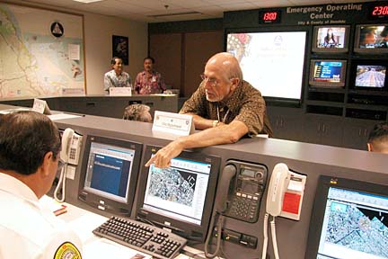
The city's redesigned emergency operations center officially opened yesterday to better deal with terrorist attacks. It has the latest technology, including 16 computer stations and a large digital-display "smart board." Assistant Civil Defense Director Joe Magaldi talked with a worker using one of the computers.
City unveils emergency Within hours of hijacked jetliners crashing into the World Trade Center last Sept. 11, city emergency planners rolled out maps of Oahu on conference tables and plotted anti-terrorist measures with grease pencils on a large, glass-covered map.
operations site
The high-tech center was
redesigned to handle situations
like the 9/11 attacksBy Nelson Daranciang
ndaranciang@starbulletin.comThe next time an emergency is declared on Oahu, planners will plot and track their strategies from individual computer stations and on a large digital-display "smart board" in the emergency operations center in the basement of the Honolulu Municipal Building.
The computer stations, 16 in all, and smart board are part of the city's redesigned emergency center, officially opened yesterday.
While Mayor Jeremy Harris praised the job by emergency planners on Sept. 11, he said it was clear the city needed to improve its information management capabilities. "We realized that we were not adequately prepared" to handle all emergency scenarios, Harris said.
The old emergency center was primarily a fallout shelter designed to respond to natural disasters, said acting Oahu Civil Defense Administrator Doug Aton. He said the events of Sept. 11 forced emergency planners to shift their attention to weapons of mass destruction.
The city Geographic Information System consisted of individual maps displaying streets and highways, streams, utility lines, location of shelters, flood-prone intersections and roadblocks. Added to that are satellite pictures of Oahu displayed on the smart board in the new center.
CRAIG T. KOJIMA / CKOJIMA@STARBULLETIN.COM
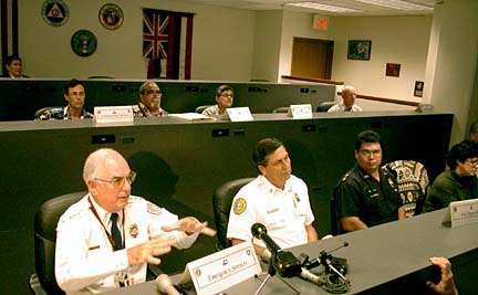
A three-tiered seating system gives workers a view of screens displaying city vehicle locations from Global Positioning System transmitters. At bottom left, Robin McCulloch, chief of Emergency Medical Services, explained his department's role.
Touch any spot on the screen, and the system will zoom in on that location. The street, utility, shelter and other maps, now stored electronically, can be displayed individually or combined and integrated into the satellite pictures.
Global Positioning System transmitters allow emergency planners to plot the location of city ambulances and Parks Department vehicles on the smart board. The Honolulu Fire Department will soon be adding GPS transmitters to fire engines.
The city is also working with the Pacific Disaster Center on Maui to integrate images generated by the National Weather Service with the Oahu satellite pictures, said Courtney Harrington, city information technology director.
Emergency planners can get real-time images of what is happening on the ground by manipulating the city's 120 traffic cameras.
The improvements to the emergency center, which cost $70,000, was completed by the city departments of Facility Maintenance, Planning & Permitting and Information Technology.
"We hope the state Civil Defense will follow our lead," said Ben Lee, city managing director. "We would love to help the other counties."