
|
Hurricane Hawaii residents should expect above-average storm activity during hurricane season, June 1 to Nov. 30, and start preparing now, said Tom Heffner, a meteorologist with the Central Pacific Hurricane Center.
preparedness urged
Above-average storm activity
Anatomy of a hurricane
in the Pacific is forecast this year,
a weather expert warns
Categories
Damage control
Advice from the experts
LinksBy Pat Gee
pgee@starbulletin.comHeffner, the hurricane warning coordinator, will be among Hawaii officials at a press conference tomorrow as part of Hurricane Awareness Week, which starts today.
The average number of "tropical cyclones," which includes all storms, depressions and hurricanes, is four to five per season, he said. Heffner plans to give out detailed information tomorrow on this season's forecast.
A mild to moderate El Nino is forecast this year in the Pacific, which means increased tropical storm and hurricane activity.
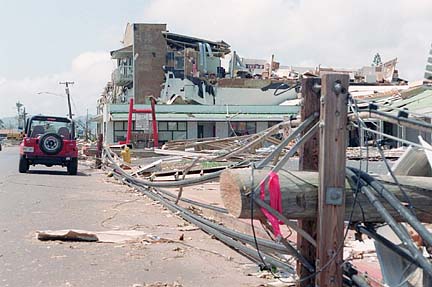
People have become rather complacent about preparing for hurricanes since Iniki devastated Kauai on Sept. 11, 1992, Heffner said.
"The challenge is convincing those who have not had a recent brush with a hurricane that they are just as susceptible as the folks on Kauai," Heffner said. "The level of preparedness of people on Kauai is much greater than on any other island because of the experience they've had."
The most important thing is to have an action plan, which includes having a rendezvous point for family members in case of a storm, he said.
"Everyone should have a survival kit," he added.
"Water is at the top of the list. Then a battery-powered radio as a way to get information on the weather. I can't stress enough having a supply of dry goods -- food," he said.
People should also know what kind of risk their home is vulnerable to and take appropriate action. If their home is not in a coastal or flood zone, it may be at risk to high winds if it is located atop a hillside, Heffner said.
He recommended that residents refer to the disaster preparedness section at the beginning of the phone book for information on what to assemble for a survival kit and how to prepare for a hurricane.
BACK TO TOP
|
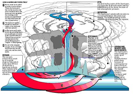
ANATOMY OF A HURRICANE
Hurricanes are generally defined as tropical cyclones with winds that reach sustained speeds of 74 mph or more. There have been a few that have caused major damage to the Hawaiian Islands in the past 50 years. Experts say hurricanes are rare occurances here because the islands are a relatively small target, far from areas prone to tropical storm genesis. Hawaii is also protected by vertical wind shear (change of wind speed and direction from near the ocean surface up to an altitude of about 8 miles), which is a major disrupter of hurricane formation.
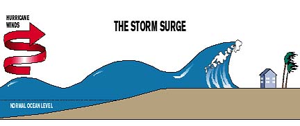
THE STORM SURGE
A storm surge is a dome of water 50 miles wide that sweeps the coastline near the area where the hurricane hits land. The low pressure in the hurricane acts like a plunger, pulling up the water level and unleashing massive waves. Storm surges are responsible for 90 percent of all hurricane-related fatalities.
BACK TO TOP
|
CATEGORIES
The Saffir-Simpson Hurricane Scale is a 1-to-5 rating based on hurricane intensity. This is used to give an estimate of the potential property damage and flooding expected along the coast from a hurricane landfall. The scale was created in 1969.
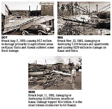
CATEGORY WINDS (MPH) DAMAGE STORM SURGE (FT) EXAMPLES 1 74-95 Minimal damage to vegetation 4-5 Dot, 1959; and Iwa, 1982 (Hawaii) 2 96-110 Moderate damage to houses 6-8 Kate, 1985 (Fla.) 3 111-130 Extensive damage to small buildings 9-12 Alicia, 1983 (Texas) 4 131-155 Extreme structural damage 13-18 Iniki, 1992 (Hawaii); Andrew, 1992 (Fla.) 5 155 plus Catastrophic building failure possible 18 plus Camille, 1969 (La. & Miss.) BACK TO TOP
|
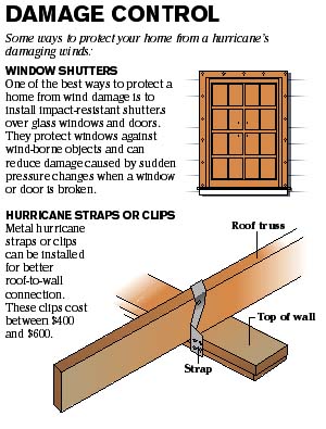
DAMAGE CONTROL
BACK TO TOP
|
Recommendations on what to do before, during and after a hurricane: STAY OUT OF HARM'S WAY
Stay or leave?
When a hurricane threatens your area, you will have to decide whether you should evacuate or whether you can ride out the storm in safety at home. If local authorities recommend evacuation, you should leave!If you live on the coastline, an offshore island, near a stream/river or in a flood plain, a high-rise or mobile home, plan to leave.
If you live in a sturdy structure and away from coastal and rainfall flooding, consider staying.
At the beginning of hurricane season
>> Learn the elevation and the flooding and wind damage history of your area.
>> Learn safe routes inland if you live near the coast.
>> Learn location of official shelters.
>> Determine where to move your boat in an emergency.
>> Trim back dead wood from trees.
>> Check for loose rain gutters and downspouts.
>> If shutters do not protect windows, stock tape and boards to cover glass.
When a hurricane watch is issued
>> Check often for official bulletins on radio, television, or National Oceanic and Atmospheric Administration Weather Radio.
>> Fuel car.
>> Moor small craft or move to safe shelter.
>> Stock up on canned provisions.
>> Check supplies of special medicines and drugs.
>> Check batteries for radio and flashlights.
>> Secure lawn furniture and other loose material outdoors.
>> Tape, board or shutter windows to prevent shattering.
>> Wedge sliding glass doors to prevent their lifting from their tracks.
When a hurricane warning is issued
>> Stay tuned to radio, TV or NOAA Weather Radio for official bulletins.
>> Stay home if sturdy and away from the coast.
>> Board up garage and porch doors.
>> Move valuables to upper floors.
>> Bring in pets.
>> Fill containers (bathtub) with several days' supply of drinking water.
>> Turn up refrigerator to maximum cold and don't open unless necessary.
>> Use phone only for emergencies.
>> Stay indoors on the downwind side of the house, away from windows.
>> Beware of the eye of the hurricane.
>> Leave areas that might be affected by storm tide or stream flooding.
>> Leave early, in daylight if possible.
>> Shut off water and electricity at main stations.
>> Take small valuables and papers, but travel light.
>> Leave food and water for pets (shelters will not take them).
>> Lock up house.
>> Drive carefully to nearest designated shelters using recommended evacuation routes.
After the "all-clear" is given
>> Drive carefully; watch for dangling electrical wires, undermined roads, flooded low spots.
>> Don't sight-see.
>> Report broken or damaged water, sewer and electrical lines.
>> Use caution when re-entering home. Check for gas leaks. Check for food and water spoilage.
Source: Civil Defense Agency and National Oceanic and Atmospheric Administration
BACK TO TOP
|
SOURCES
City and County of Honolulu: www.co.honolulu.hi.us
National Hurricane Center: www.nhc.noaa.gov
Navy Region Hawaii Public Affairs Office: www.hawaii.navy.mil
Accuweather: accuweather.com
San Diego State University: edweb.sdsu.edu
Hurricanes 2002 dot Com: www.hurricanes98.comRESEARCH AND GRAPHICS BY KIP AOKI / KAOKI@STARBULLETIN.COM