
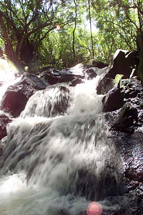
Surveys begin to The lack of a road forces visitors and residents to walk along Pali Highway to get to Kapena Falls in Nuuanu.
save Kapena Falls
Residents express concerns over
hiker safety and pollutionBy Kelliann Shimote
kshimote@starbulletin.comConcerned residents in neighboring areas are raising questions regarding hikers' safety and the preservation of the site.
So the city's vision team project, supported by the Nuuanu and Liliha neighborhood board, wants to survey the area to preserve the falls.
The area first drew attention because of the pollution.
"It was desecrated by people and by plants, that is why it was chosen," said chairwoman Paula Kurashige of Neighborhood Board 12. "I even saw refrigerators that were dumped in there. People were not truthful to the area."
Safety is another issue.
"The original intent of the vision group was to find a safe route to Kapena Falls because they were concerned about residents and tourists walking Pali Highway," said Loretta Chee, deputy director of the city Planning Department.
"At the same time, they recognized this was an area that was rich in culture and historical resources, and they asked that part of the study include identifying what resources were there."
As a result, Lester Inouye, vision team consultant and city landscape architect, has hired land surveyors to develop a map of the Kapena Falls area.
"At this point, we would like to see exactly what is there and see how to preserve it," Inouye said.
The area presents a challenge because it is overgrown with banyan trees, java plum trees and vines. These plants make it difficult for archaeologists to further map the site.
An initial tour visited the site on June 28.
"We would like the archaeologist to take an inventory of what is actually down there," Inouye said.So far, archaeologists are looking to see the impact the banyan trees have on the stream. They are also observing the agricultural terraces, which once grew taro.
"If there are any that are damaging the archeology site, in some cases we have dead trees that should be removed before they fall over ... if there is some vegetation clearing, we will go back and check if something has been exposed," state parks interpretive program supervisor Martha Yent said.
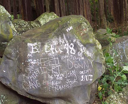
Graffiti is also another one of the concerns that threaten existing petroglyphs.
"You walk along the trail now, you'll see a lot of scratching on the rock faces. So there is vandalism that is occurring on the rock faces along the streams," Yent said.
An archaeology survey began on Thursday, to be followed by a topographic mapping of the site. After these reconstructive efforts, Inouye hopes to reintroduce native Hawaiian plants that will sustain itself.
According to Chee, funds are provided by the capital improvement budget. So far the contract is about $100,000.
"We would like to see exactly what is there and see how it could be preserved ... we don't have any preconceived ideas yet," Inouye said.